Zhi Li

and 10 more

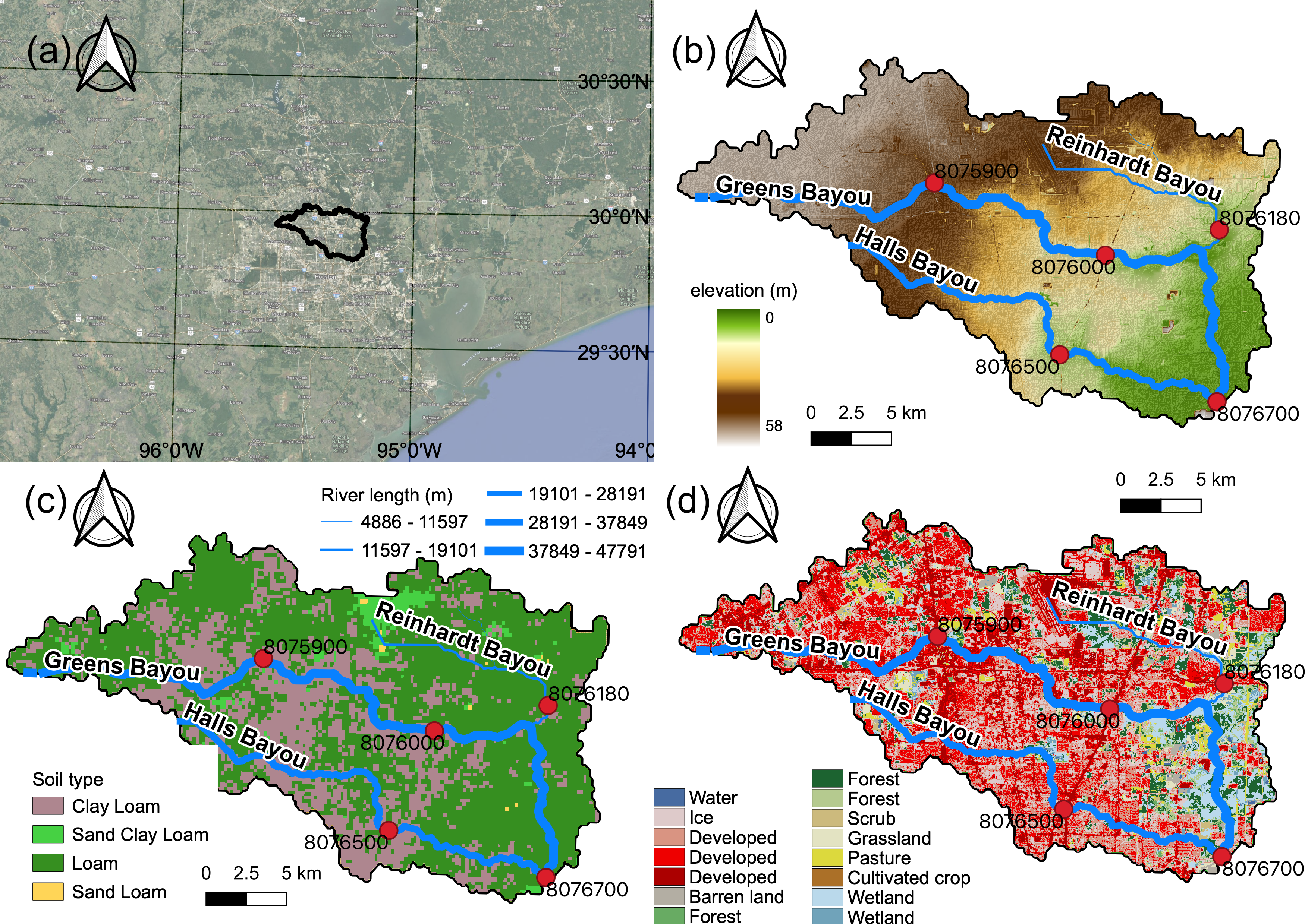
Effective flash flood forecasting and risk communication are imperative for mitigating the impacts of flash floods. However, the current forecasting of flash flood occurrence and magnitude largely depends on forecasters’ expertise. An emerging flashiness-intensity-duration-frequency (F-IDF) product is anticipated to facilitate forecasters by quantifying the frequency and magnitude of an imminent flash flood event. To make this concept usable, we develop two distributed F-IDF products across the contiguous US, utilizing both a Machine Learning (ML) approach and a physics-based hydrologic simulation approach that can be applied at ungaged pixels. Specifically, we explored 20 common ML methods and interpreted their predictions using the Shapley Additive exPlanations method. For the hydrologic simulation, we applied the operational flash flood forecast framework – EF5/CREST. It is found that: (1) both CREST and ML depict similar flash flood hot spots across the CONUS; (2) The ML approach outperforms the CREST-based approach, with the drainage area, air temperature, channel slope, potential evaporation, soil erosion identified as the five most important factors; (3) The CREST-based approach exhibits high model bias in regions characterized by dam/reservoir regulation, urbanization, or mild slopes. We discuss two application use cases for these two products. The CREST-based approach, with its dynamic streamflow predictions, can be integrated into the existing real-time flash flood forecast system to provide event-based forecasts of the frequency and intensity of floods at multiple durations. On the other hand, the ML-based approach, which is a static measure, can be integrated into a flash flood risk assessment framework for urban planners.

Xiao-Ming Hu

and 10 more

Planetary boundary layer (PBL) schemes parameterize unresolved turbulent mixing within the PBL and free troposphere (FT). Previous studies reported that precipitation simulation over the Amazon in South America is quite sensitive to PBL schemes and the exact relationship between the turbulent mixing and precipitation processes is, however, not disentangled. In this study, regional climate simulations over the Amazon in January-February 2019 are examined at process level to understand the precipitation sensitivity to PBL scheme. The focus is on two PBL schemes, the Yonsei University (YSU) scheme, and the asymmetric convective model v2 (ACM2) scheme, which show the largest difference in the simulated precipitation. During daytime, while the FT clouds simulated by YSU dissipate, clouds simulated by ACM2 maintain because of enhanced moisture supply due to the enhanced vertical moisture relay transport process: 1) vertical mixing within PBL transports surface moisture to the PBL top, and 2) FT mixing feeds the moisture into the FT cloud deck. Due to the thick cloud deck over Amazon simulated by ACM2, surface radiative heating is reduced and consequently the convective available potential energy (CAPE) is reduced. As a result, precipitation is weaker from ACM2. Two key parameters dictating the vertical mixing are identified, p, an exponent determining boundary layer mixing and λ, a scale dictating FT mixing. Sensitivity simulations with altered p, λ, and other treatments within YSU and ACM2 confirm the precipitation sensitivity. The FT mixing in the presence of clouds appears most critical to explain the sensitivity between YSU and ACM2.

Zhi Li

and 8 more

Precipitation is an essential climate and forcing variable for modeling the global water cycle. Particularly, the Integrated Multi-satellitE Retrievals for GPM (IMERG) product retrospectively provides unprecedented two-decades of high-resolution satellite precipitation estimates (0.1-deg, 30-min) globally. The primary goal of this study is to examine the similarities and differences between the two latest and also arguably most popular GPM IMERG Early and Final Run (ER and FR) products systematically over the globe. The results reveal that: (1) ER systematically estimates 13.0% higher annual rainfall than FR, particularly over land (13.8%); (2) ER and FR show less difference with instantaneous rates (Root Mean Squared Difference: RMSD=2.38 mm/h and normalized RMSD: RMSD_norm=1.10), especially in Europe (RMSD=2.16 mm/h) and cold areas (RMSD_norm=0.87); and (3) with similar detectability of extreme events and timely data delivery, ER is favored for use in hydrometeorological applications, especially in early warning of flooding. Throughout this study, large discrepancies between ER and FR are found in inland water bodies, (semi) arid regions, and complex terrains, possibly owing to morphing differences and gauge corrections while magnified by surface emissivity and precipitation dynamics. The exploration of their similarities and differences provides a first-order global assessment of various hydrological utilities: FR is designed to be more suitable for retrospective hydroclimatology and water resource management, while the earliest available ER product, though not bias-corrected by ground gauges, shows suitable applicability in operational modeling setting for early rainfall-triggered hazard alerts.

Zoi Dokou

and 13 more

The Blue Nile Basin, Ethiopia, whose inter-annual variability in local precipitation has resulted in droughts and floods that lead to economic and food insecurity, is the area of interest for our NSF-PIRE project, which aims to develop novel forecast technologies to mitigate the stresses to local communities. As part of the PIRE project, a Citizen Science Initiative (PIRE CSI) was established in June 2017, a project that trains high school students in hydrologic data collection under the guidance of classroom teachers and graduate students and professors from Bahir Dar University in four watersheds of interest, located south of Lake Tana, Ethiopia. Four MSc graduate students were selected from Bahir Dar University and trained nine high school students who were nominated taking into account gender and the proximity of their schools to the watersheds. High school students are currently collecting soil moisture data using TDR, river stage measurements using optical levels and groundwater levels using shallow water level meters. The data collection is supported by an app (B-WING), developed specifically for the needs of the project. College-ready activities are being planned for the high school students, i.e. inviting them to Bahir Dar University to analyze some of the data, present their work at a workshop, and familiarize themselves with the university experience. Recently, the PIRE CSI was extended to involve local farmers as “citizen scientists”, collecting soil moisture data using low-cost, soil moisture sensors developed in-house at the University of Connecticut, that have been installed in 12 locations and two soil depths (20 cm and 40 cm). The collected data will be used for the initialization and validation of the hydrological models developed in the region. The PIRE CSI promotes the empowerment of local communities and establishes long-lasting partnerships between scientists and stakeholders. It is believed that the co-generation of knowledge may contribute to higher rates of forecast adaption by the local farmers and may trigger the student’s interest in STEM and encourage their uptake of scientific careers. Acknowledgment: This material is based upon work supported by the National Science Foundation under Grant No. 1545874.

Zhi Li

and 7 more

Coupled Hydrologic & Hydraulic (H&H) models have been widely applied to simulate both discharge and flood inundation due to their complementary advantages, yet the H&H models oftentimes suffer from one-way and weak coupling and particularly disregarded run-on infiltration or re-infiltration. This could compromise the model accuracy, such as under-prediction (over-prediction) of subsurface water contents (surface runoff). In this study, we examine the H&H model performance differences between the scenarios with and without re-infiltration process in extreme events¬ – 100-year design rainfall and 500-year Hurricane Harvey event – from the perspective of flood depth, inundation extent, and timing. Results from both events underline that re-infiltration manifests discernable impacts and non-negligible differences for better predicting flood depth and extents, flood wave timings, and inundation durations. Saturated hydraulic conductivity and antecedent soil moisture are found to be the prime contributors to such differences. For the Hurricane Harvey event, the model performance is verified against stream gauges and high water marks, from which the re-infiltration scheme increases the Nash Sutcliffe Efficiency score by 140% on average and reduces maximum depth differences by 17%. This study highlights that the re-infiltration process should not be disregarded even in extreme flood simulations. Meanwhile, the new version of the H&H model – the Coupled Routing and Excess STorage inundation MApping and Prediction (CREST-iMAP) Version 1.1, which incorporates such two-way coupling and re-infiltration scheme, is released for public access.

Farinaz Gholami

and 4 more

The Digital Elevation Model (DEM) of a watershed is one of the most important inputs in most hydrological analyses and plays a key role in the accurate prediction of various hydrological processes. Comprehensive knowledge of the impact of different DEM sources on the performance of a model is essential before utilizing the model. In this study, we evaluated the influence of TOPO1:25000, ASTER, and SRTM DEMs, as input, on the performance of the Soil and Water Assessment Tool (SWAT) model for the prediction of surface runoff. We also investigated the effect of the resolution of the studied DEM sources on the accuracy of the SWAT model in the estimation of runoff. The second objective of this study was to identify the most influential and the least impactful input parameters on the performance of the SWAT model. We studied the Zarrineh River watershed in Iran as a case study to compare the effect of the aforementioned DEM types and DEM resolution on the output of the SWAT model. The outcomes of the study demonstrated that influential parameters on predicted runoff as well as a few watershed parameters, such as reach lengths, reach slopes, number of sub-basins, and the number of hydrologic response units (HRU), differs noticeably when the DEM source and resolution changes. It was also observed that simulated results over-predict the runoff during low precipitation periods and under-predict the runoff during high precipitation months, and the accuracy of the simulated results decreases by reducing the DEM resolution. The results showed that the SWAT model had the best performance when the TOPO1:25000 DEM was used as the input source. Low-resolution DEMs are available to a wider range of researchers. The outcomes of the current study can be employed to estimate the impact of low-resolution input data on the simulated result as well as substantially reduce the computation time by decreasing the input DEMresolution with only a minor reduction of accuracy.