Diego Melgar

and 5 more

Large earthquakes are difficult to model in real-time with traditional inertial seismic measurements. Several algorithms that leverage high-rate RT-GNSS positions have been proposed and it has been shown that they can supplement the earthquake monitoring effort. However, analyses of the long-term noise behavior of high-rate RT-GNSS positions, which are important to understand how the data can be used operationally by monitoring agencies, have been limited to just a few sites and to short time spans. Here we show results from an analysis of the noise characteristics of one year of positions at 213 RT-GNSS sites spanning a large geographic region from Southern California to Alaska. We characterize the behavior of noise and propose several references noise models which can be used as baselines to compare against as technological improvements allow for higher precision solutions. We also show how to use the reference noise models to generate realistic synthetic noise that can be used in simulations of HR-GNSS waveforms. We discuss spatiotemporal variations in the noise and their potential sources and significance. We also detail how noise analysis can be used in a dynamic quality control to determine which sites should or should not contribute positions to an earthquake modeling algorithm at a particular moment in time. We posit that while there remain important improvements yet to be made, such as reducing the number of outliers in the time series, the present quality of real-time HR-GNSS waveforms is more than sufficient for monitoring large earthquakes.

William Wilcock

and 10 more

We report on a feasibility study for an offshore instrument network in the Cascadia subduction zone to improve earthquake and tsunami early warning. The global DART buoy network provides effective warning for far-field tsunamis but near-field tsunami warning is challenging because the lead time is short and near-source observations are rarely available to directly measure the sea surface disturbance and evolution. Near-field tsunami warnings presently rely on rapid point source seismic inversions that do not estimate tsunami wave height. Efforts are underway to incorporate GNSS data into rapid source inversions that would support an initial near-field tsunami prediction. Offshore observations would contribute further to near-field tsunami warnings by providing: first, direct observations of seafloor and sea surface displacements during earthquake rupture and second, ongoing measurements for continued forecast refinement. Offshore instruments could also detect tsunamis triggered by submarine landslides and by so-called “tsunami” or “slow” or “silent” earthquakes that can generate unexpectedly large tsunamis but are characterized by shaking intensity so low as to be undetected or ignored. Pressure observations in the source zone will be challenging to interpret because they are dominated by seafloor accelerations and hydroacoustic waves rather than changes in hydrostatic pressure. In an effective system, pressure observations may need to be complemented by other observations such as inertial measurements of seafloor displacement, GNSS buoys and high-frequency coastal radar. It may also be important to place pressure sensors just seaward of the source zone to measure the developing tsunami in a region with an undisturbed seafloor. We will discuss alternative design options for an offshore instrument network in Cascadia, the research and development that must to be completed to determine the best approach, and the role of offshore observations in a holistic plan for tsunami mitigation.

David T Small

and 1 more

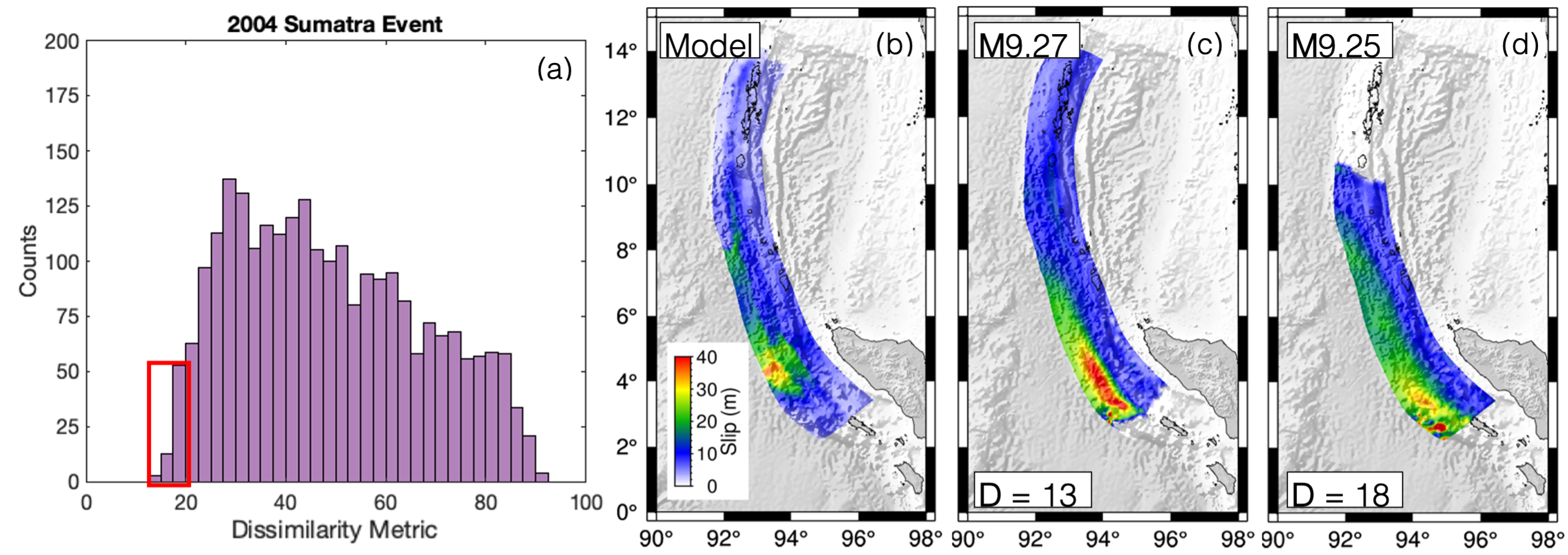
Stochastic slip rupture modeling is a computationally efficient reduced-physics approximation that has the capability to create any number of unique ruptures based only on a few statistical assumptions. Its simplicity and efficiency make it an attractive and viable option for testing early warning systems, hazard assessments, and infrastructure response studies. Yet a fundamental question pertaining to this approach is whether the slip distributions calculated in this way are “realistic”. More specifically, can stochastic modeling reproduce slip distributions that match what is seen in M9+ events recorded in instrumental time? Here, we start with the 2011 M9.1 Tohoku-oki earthquake and tsunami where we test both a stochastic method with a homogeneous background mean model and a method where slip is informed by an additional interseismic coupling constraint. We test two coupling constraints with varying assumptions of either trench-locking or -creeping and assess their influence on the calculated ruptures. We quantify the dissimilarity of slip distribution between the 12,000 modeled ruptures and a slip inversion for the Tohoku earthquake. We also model tsunami inundation for over 300 ruptures and compare the results to an inundation survey along the eastern coastline of Japan. We conclude that stochastic slip modeling can produce ruptures that can be considered “Tohoku-like”, and inclusion of coupling can both positively and negatively influence the ability to create realistic ruptures. We then expand our study and show that for the 1960 M9.4-9.6 Chile and 2004 M9.1-9.3 Sumatra events, stochastic slip modeling has the capability to produce realistic ruptures.

David T Small

and 1 more

Current stochastic rupture modeling techniques do not consider the influence of first order fault zone characteristics. One such key characteristic is fault slip deficit or inter-seismic locking which has shown correlation between areas of high coupling and areas of greater slip in many recent large ruptures globally. Therefore, it is reasonable to assume that it should be considered as prior information in rupture modeling. Here, we first present a mathematical formalism to introduce locking models as prior information into stochastic rupture modeling. We then focus on how introducing slip deficit information into the stochastic rupture models influences slip distributions for the Cascadia Subduction Zone (CSZ). We compare rupture models created with two end member models of locking, one with a fully locked zone extending to the trench and another with locking deeper downdip, along with models created without a prior knowledge of locking. Large variations occur and correlate well with areas with the largest differences in slip deficit. To exemplify their impacts, the ruptures are then used for probabilistic tsunami hazard assessment. We find that overall the tsunami amplitudes generated are much more hazardous in the northern extent of the CSZ where differences in locking distribution are more prevalent. Although large uncertainties are present in accuracy of locking, imposing either constraint created very different hazard estimations when compared to the hazards where no prior locking information was used. This highlights the necessity to expand seafloor instrumentation and to consider first order fault information like locking in future authoritative hazard assessments.