Mantle convection plays a fundamental role in driving evolution of oceanic and continental lithosphere. In turn it impacts a broad suite of processes operating at or close to Earth’s surface including landscape evolution, glacio-eustasy, magmatism and climate. A variety of theoretical approaches now exist to simulate mantle convection. Outputs from such simulations are being used to parameterise models of landscape evolution and basin formation. However, the substantial body of existing simulations has generated a variety of conflicting views on the history of dynamic topography, its evolution and key parameters for modelling mantle flow. The focus of this study is on developing strategies to use large-scale quantitative stratigraphic observations to asses model predictions and identify simulation parameters that generate realistic predictions of Earth surface evolution. Spot measurements of uplift or subsidence provide useful target observations but are often controlled by tectonic processes, yet avoiding areas where tectonics have influenced vertical motions is challenging. To address this issue, we use large inventories of stratigraphic data from across North America with contextual geophysical and geodetic data to constrain the regional uplift and subsidence history. We demonstrate that a suite of fairly typical simulations struggle to match the amplitude, polarity and timing of observed vertical motions. Building on recent seismological advances, we then explore strategies for understanding patterns of continental uplift and subsidence that incorporate (and test) predicted evolution of the lithosphere, asthenosphere and deep mantle. Our results demonstrate the importance of contributions from the uppermost mantle in driving vertical motions of continental interiors.
The modern state of the mantle and its evolution on geological timescales is of widespread importance for the Earth sciences. For instance, it is generally agreed that mantle flow is manifest in topographic and drainage network evolution, glacio-eustasy and in the distribution of sediments. There now exists a variety of theoretical approaches to predict histories of mantle convection and its impact on surface deflections. A general goal is to make use of observed deflections to identify Earth-like simulations and constrain the history of mantle convection. Several important insights into roles of radial and non-radial viscosity variations, gravitation, and the importance of shallow structure already exist. Here we seek to bring those insights into a single framework to elucidate the relative importance of popular modelling choices on predicted instantaneous vertical surface deflections. We start by comparing results from numeric and analytic approaches to solving the equations of motion that are ostensibly parameterised to be as-similar-as-possible. Resultant deflections can vary by $\sim$10\%, increasing to $\sim25$\% when viscosity is temperature-dependent. Including self-gravitation and gravitational potential of the deflected surface are relatively small sources of discrepancy. However, spherical harmonic correlations between model predictions decrease dramatically with the excision of shallow structure to increasing depths, and when radial viscosity structure is modified. The results emphasise sensitivity of instantaneous surface deflections to density and viscosity anomalies in the upper mantle. They reinforce the view that a detailed understanding of lithospheric structure is crucial for relating mantle convective history to observations of vertical motions at Earth’s surface.
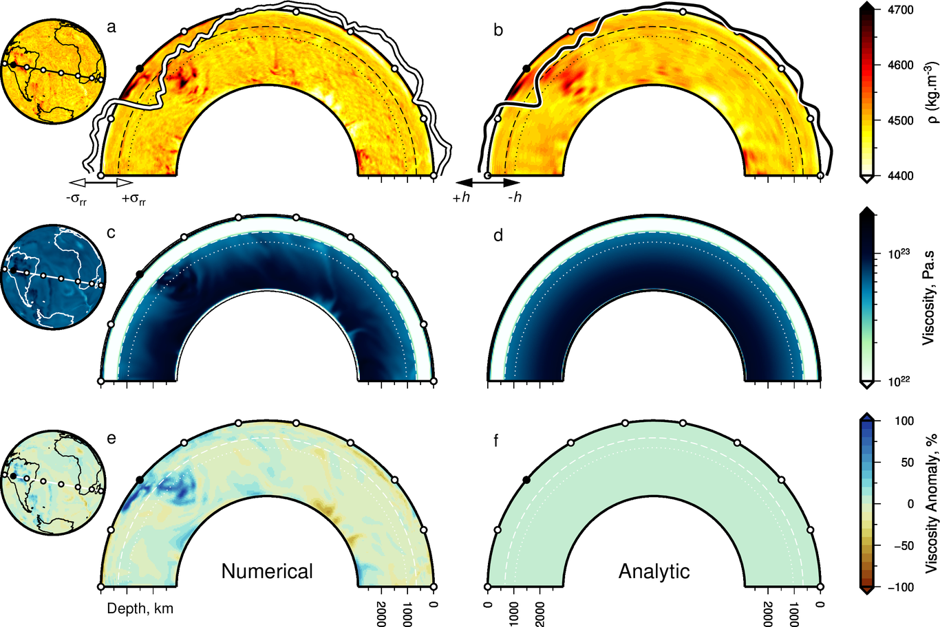
The modern state of the mantle and its evolution over geological timescales is of widespread importance for the Earth sciences. For instance, it is generally agreed that mantle flow is manifest in topographic and drainage network evolution, glacio-eustasy, volcanism, and in the distribution of sediments. An obvious way to test theoretical understanding of mantle convection is to compare model predictions with independent observations. We take a step towards doing so by exploring sensitivities of theoretical surface deflections generated from a systematic exploration of global mantle convection simulations. Sources of uncertainty, model parameters that are crucial for predicting deflections, and those that are less so, are identified. We start by quantifying similarities and discrepancies between deflections generated using numerical and analytical methods that are ostensibly parameterised to be as-similar-as-possible. Numerical approaches have the advantage of high spatial resolution, and can capture effects of lateral viscosity variations. However, treatment of gravity is often simplified due to computational limitations. Analytic solutions, which leverage propagator matrices, are computationally cheap, easy to replicate, and can employ radial gravitation. However, spherical harmonic expansions used to generate solutions can result in coarser resolution, and the methodology cannot account for lateral viscosity variations. We quantify the impact of these factors for predicting surface deflections. We also examine contributions from radial gravity variations, perturbed gravitational potential, excised upper mantle, and temperature-dependent viscosity, to predicted surface deflections. Finally, we quantify effective contributions from the mantle to surface deflections. The results emphasise the sensitivity of surface deflections to the upper mantle.

Victoria Fernandes

and 1 more

Vertical motions of Earth’s surface are used to inform almost all branches of the Earth Sciences, and central role in understanding geological, biological and climatic processes. An important challenge is generating enough information to reliably constrain histories of vertical motion. Significant effort has been expended in generating information about denudation (e.g. from thermochronometry), uplift (e.g. from stable isotopes or drainage analyses) and subsidence patterns. However, a canonical inventory of measurements that determine continental uplift on timescales pertinent to growth and decay of continental topography does not exist. We address this issue using the distribution of unequivocally marine rock recorded in new, detailed, paleobiological inventories. We show that these new compilations of paleobiological and paleoenvironmental data, that were generated to address paleobiological problems, also provide an unprecedented number of self-consistent, high-resolution measurements of continental and ocean island uplift. We focus on the Cretaceous to Recent history, which captures the large-scale marine incursions of the continents. Our results highlight that significant improvements can be made in understanding the histories of the continents in using these measurements of uplift. We present examples from North and South America, southern Africa and Australia to show how this new database can be explored to better understand the processes that generate high topography. They emphasize the importance of large inventories of paleobiological data for understanding long-wavelength uplift and the role tectonic and mantle convective processes play in generating continental topography.

Victoria Fernandes

and 3 more

Reconstructing patterns of topographic evolution is key to our understanding of the various processes responsible for landscape development. Suites of existing geodynamic models suggest the North American landscape has been influenced by a history of evolving dynamic support. This study investigates the extent to which this process has played a role in generating the elevation and long-wavelength topographic relief observed. Review of studies investigating distribution of magmatism, marine sedimentary rocks, sediment flux, thermochronology models, paleoaltimetry and geomorphic analyses all point towards a staged uplift history of North America since the Late Cretaceous. Another way to investigate regional uplift is to use deposits of known age, containing paleo-water depth indicators, as a datum against which post-depositional uplift can be measured. Compilations of paleobathymetry from interpreted biostratigraphic and stratigraphic markers, compared to their present-day elevations, are therefore exploited to give detailed geologic constraints on surface uplift. Our results indicate > 2 km of long-wavelength differential uplift has developed in the continental interior during the Cenozoic. In conjunction with these datasets, the uplift history of North America can be calculated by considering the geomorphic evolution of continental drainage. Results of a calibrated inverse stream-power model are presented, where > 4000 river longitudinal profiles are used to calculate best-fitting smooth spatio-temporal histories of uplift rate. The resulting model also points towards a staged uplift history in most regions of high elevation. Evaluation of results using the biostratigraphic and stratigraphic databases shows the model is broadly consistent with the geological record. As a further validation of the inversion we present a continental landscape evolution model, fed with the uplift history and erosional parameters from the inversion. This outputs elevation, discharge, denudation and sedimentary flux histories that are consistent with our inverse modeling schemes and compiled datasets of sediment flux and low temperature thermochronology. Data and modeling results are in agreement with geodynamic models predicting > 1 km dynamic support of the North American continent.