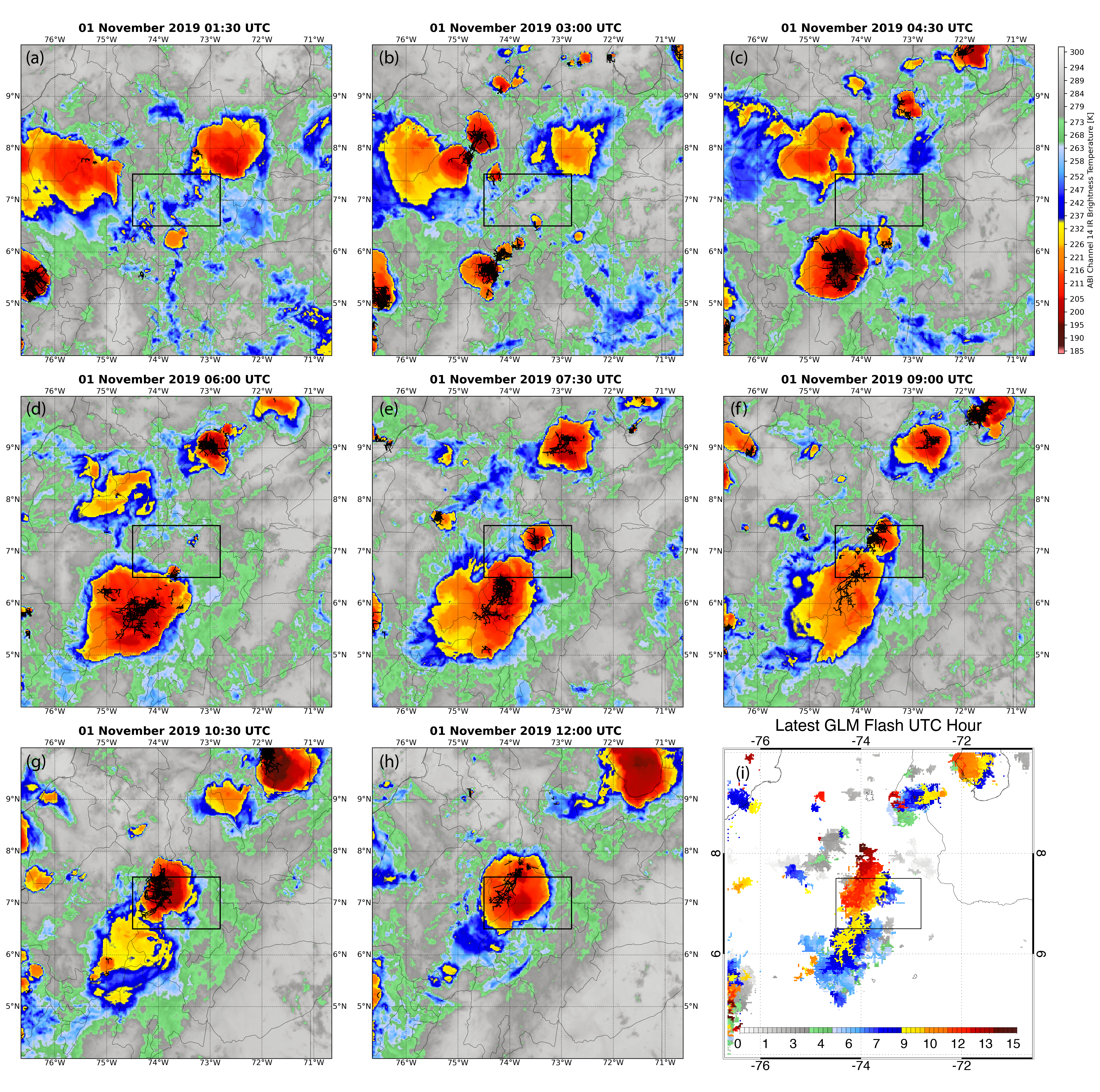
We previously documented geographic distributions of the optically brightest lightning on Earth – known as “superbolts” – using two space-based instruments: the photodiode detector (PDD) on the Fast On-orbit Recording of Transient Events (FORTE) satellite and the Geostationary Lightning Mapper (GLM) on NOAA’s newest Geostationary Operational Environmental Satellites (GOES). In this study, we further examine the superbolts identified by the PDD and GLM to reconcile the differences between their geographic distributions. We find that both the physical extent of the parent flash and the development speed of its leaders are important for making a superbolt. The oceanic PDD superbolts tend to occur early in flashes that rapidly expand laterally into long-horizontal “megaflashes.” The top GLM superbolts occur over land at later times in particularly large megaflashes that grow more slowly until they extend over multiple hundreds of kilometers. The FORTE PDD missed these delayed superbolts due to limitations in its triggering. Coincident TRMM measurements show that the warm season megaflash superbolts detected by LIS/GLM and Turman’s (1977) wintertime oceanic superbolts also observed by the PDD occur in otherwise similar thunderstorm environments. Both are marked by: low storm heights (< 10 km), widespread rainfall near the surface, small infrared brightness temperature gradients, and low flash rates. We suggest that the vertically-compact, stratiform nature of these clouds allows them to store more charge between flashes, providing favorable conditions for superbolt production.
It is important to understand connections between society and the natural environment for anticipating environmental hazards and anthropogenic effects on the broader Earth system. In this study, we conduct a detailed exploration of the interactions between oceanic thunderstorms and maritime traffic. Shipping traffic produces aerosols that perturb the otherwise “clean” ocean environment. Prior work proposed these aerosol effects as the cause of increased lightning activity over certain shipping lanes. However, introducing tall well-grounded objects into a high electric field environment might also facilitate lightning discharges, as we see with upward lightning over land. We consider both possibilities in this work. Our analyses of the thunderstorms responsible for the enhanced lightning activity over the shipping lane with the clearest anthropogenic signal indicate that the anthropogenic signature results from an increased frequency of lightning-producing storms. We did not find evidence of variations in the microphysical parameters describing the storms over shipping lanes and other nearby oceanic regions that might suggest aerosol effects. In contrast, matching lightning stroke data with ship transponder events in oceanic regions where public data are available reveals a strong signal from direct ship interactions with lightning that results in a 1-2 orders of magnitude increase in stroke frequency at current ship locations compared to other nearby regions. These results highlight the central role of direct ship interactions in explaining lightning enhancements over shipping lanes. We also document the frequency of these direct lightning interactions across various categories of vessels and on individual ships present in the public data.
Lightning is measured from space using optical instruments that detect transient changes in the illumination of the cloud top. How much of the flash (if any) is recorded by the instrument depends on the instrument detection threshold. NOAA’s Geostationary Lightning Mapper (GLM) employs a dynamic threshold that varies across the imaging array and changes over time. This causes flashes in certain regions and at night to be recorded in greater detail than other flashes, and threshold inconsistencies will impose biases on all levels of GLM data products. In this study, we quantify the impact of the varying GLM threshold on event / group detection, flash clustering, and gridded product generation by imposing artificial thresholds on the event data taken from a thunderstorm with a low instrument threshold (~0.7 fJ). We find that even modest increases in threshold severely impact event (60% loss by 2 fJ, 90% loss by 10 fJ) and group (25% loss by 2 fJ, 81% loss by 10 fJ) detection by suppressing faint illumination of the cloud-top from weak sources and scattering. Flash detection is impacted less by threshold increases (4% loss by 2 fJ), but reductions are still significant at higher thresholds (35% loss by 10 fJ, or 44% if single-group flashes are removed). Undetected pulses cause individual flashes to be split and severely impact the construction of gridded products. All these factors complicate the interpretation of GLM data, particularly when trended over time under a changing threshold.
Optical space-based lightning sensors such as the Geostationary Lightning Mapper (GLM) detect and geolocate lightning by recording rapid changes in cloud-top illumination. While lightning locations can be determined to within a pixel on the GLM imaging array, these instruments are not individually able to natively report lightning altitude. It has previously been shown that thunderclouds are illuminated differently based on the altitude of the optical source. In this study, we examine how altitude information can be extracted from the spatial distributions of GLM energy recorded from each optical pulse. We match GLM “groups” with LMA source data that accurately report the 3-D positions of coincident Radio-Frequency (RF) emitters. We then use machine learning methods to predict the mean LMA source altitudes matched to GLM groups using metrics from the optical data that describe the amplitude, breadth, and texture of the group spatial energy distribution. The resulting model can predict the LMA mean source altitude from GLM group data with a median absolute error of < 1.5 km, which is sufficient to determine the location of the charge layer where the optical energy originated. This model is able to capture changes to the source altitude distribution following convective invigoration or maturation, and the GLM predictions can reveal the vertical structure of individual flashes - enabling 3-D flash geolocation with GLM for the first time. Additional work is required to account for differences in thunderstorm charge / precipitation structures and viewing angle across the GLM Field of View.
Previous lightning climatologies derived from Lightning Imaging Sensor (LIS) and Optical Transient Detector (OTD) total lightning measurements have quantified lightning frequency as a Flash Rate Density (FRD). This approach assumes that lightning flashes can be represented as points, and quantifies the frequency of lightning centered in each grid cell. However, lightning has a finite extent that can reach hundreds of kilometers. A new climatology based on Flash Extent Density (FED) is constructed for LIS (including ISS-LIS) and OTD that accounts for the horizontal dimension of lightning. The FED climatology documents the frequency that an observer can expect lightning to be visible overhead - regardless of where the flash began or ended. This new FED climatology confirms and elaborates on the previous global LIS / OTD FRD and Americas-only Geostationary Lightning Mapper (GLM) findings. Applying GLM reprocessing codes to LIS and OTD data reveals cases of megaflashes measured from Low Earth Orbit that were artificially split by the LIS / OTD clustering algorithms. The FED climatology maintains Lake Maracaibo as the global lightning hotspot with an average of 389 flashes / day, but designates Karabre in the Democratic Republic of the Congo as the global thunderstorm duty (percent of the total viewtime where lightning is observed) hotspot at 7.29%. Meanwhile, Kuala Lumpur is the national capital city with the most lightning, and its airport (KUL) is the top major airport affected by lightning. The FED seasonal cycle and month-to-month changes in the “center of lightning” for the three continental chimney regions are also discussed.