Jeff Dozier

and 9 more

Chemical and biological composition of surface materials and physical structure and arrangement of those materials determine the intrinsic reflectance of Earth’s land surface. The apparent reflectance—as measured by a spaceborne or airborne sensor that has been corrected for atmospheric attenuation—depends also on topography, surface roughness, and the atmosphere. Especially in Earth’s mountains, estimating properties of scientific interest from remotely sensed data requires compensation for topography. Doing so requires information from digital elevation models (DEMs). Available DEMs with global coverage are derived from spaceborne interferometric radar and stereo-photogrammetry at ~30 m spatial resolution. Locally or regionally, lidar altimetry, interferometric radar, or stereo-photogrammetry produces DEMs with finer resolutions. Characterization of their quality typically expresses the root-mean-square (RMS) error of the elevation, but the accuracy of remotely sensed retrievals is sensitive to uncertainties in topographic properties that affect incoming and reflected radiation and that are inadequately represented by the RMS error of the elevation. The most essential variables are the cosine of the local solar illumination angle on a slope, the shadows cast by neighboring terrain, and the view factor, the fraction of the overlying hemisphere open to the sky. Comparison of global DEMs with locally available fine-scale DEMs shows that calculations with the global products consistently underestimate the cosine of the solar angle and underrepresent shadows. Analyzing imagery of Earth’s mountains from current and future spaceborne missions requires addressing the uncertainty introduced by errors in DEMs on algorithms that analyze remotely sensed data to produce information about Earth’s surface.

Shawn Serbin

and 5 more

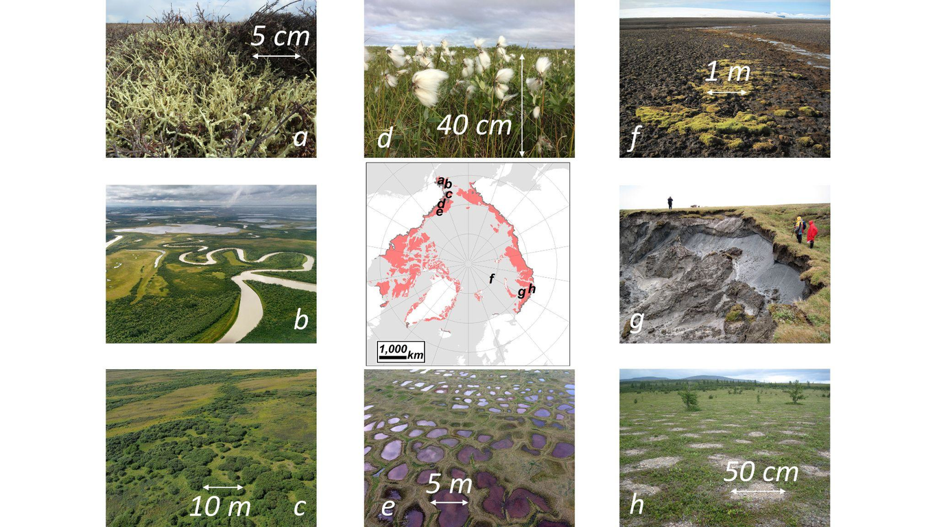
Over the last nearly five decades, optical remote sensing has played a key role in monitoring and quantifying global change, plant diversity, and vegetation functioning across Earth’s terrestrial biomes. As a key tool for researchers, land managers, and policy makers, optical remote sensing facilitates scaling, mapping, and characterizing surface properties over large areas and through time. In addition, steady technological improvements have led to transformational changes in our ability to understand ecosystem state and change, particularly through the expansion of high spectral resolution (i.e. spectroscopic) remote sensing platforms. Point and imaging spectroscopy systems have been used across a range of scales, vegetation types, and biomes to infer plant diversity, leaf traits, and ecosystem functioning. However, despite the acknowledged utility of spectroscopic systems, data availability has been limited to smaller geographic regions given a number of technical challenges, including issues related to data volume and limited spatial coverage by previous Earth Observing (EO) missions (i.e. Hyperion). The NASA Surface Biology and Geology (SBG) mission is designed to fill this gap in ecosystem monitoring. As part of the Space-based Imaging Spectroscopy and Thermal pathfindER (SISTER) and Modeling end-to-end traceability (MEET) SBG efforts, we used field, unoccupied aerial system (UAS), and airborne imagery (from NASA’s AVIRIS-NG plafrom) to evaluate the impacts of proposed and theoretical sensor instrument properties on the retrieval of vegetation reflectance across tundra, shrub, and treeline ecosystems in Alaska. Existing observations and open-source tools are used for the simulation of surface reflectance under a range of atmospheric conditions, vegetation types, and different sensor properties. We find that retrieval uncertainty is reduced across all surface types with increasing detector signal-to-noise (SNR) but also key differences across different plant types. Results were also strongly tied to sun-sensor geometry and atmospheric state. Through this exercise we highlight key outcomes to consider for the SBG mission to optimize surface reflectance retrieval in high latitudes that will help to minimize errors in down-stream algorithms, such as functional trait retrievals.

E. Natasha Stavros

and 23 more

Observations of Planet Earth from space are a critical resource for science and society. Satellite measurements represent very large investments and United States (US) agencies organize their effort to maximize the return on that investment. The US National Research Council conducts a survey of earth science and applications to prioritize observations for the coming decade. The most recent survey prioritized a visible to shortwave infrared imaging spectrometer and a multi-spectral thermal infrared imager to meet a range of needs. First, and perhaps, foremost, it will be the premier integrated observatory for observing the emerging impacts of climate change . It will characterize the diversity of plant life by resolving chemical and physiological signatures. It will address wildfire, observing pre-fire risk, fire behavior and post-fire recovery. It will inform responses to hazards and disasters guiding responses to a wide range of events, including oil spills, toxic minerals in minelands, harmful algal blooms, landslides and other geological hazards. The SBG team analyzed needed instrument characteristics (spatial, temporal and spectral resolution, measurement uncertainty) and assessed the cost, mass, power, volume, and risk of different architectures. The Research and Applications team examined available algorithms, calibration and validation and societal applications and used end-to-end modeling to assess uncertainty. The team also identified valuable opportunities for international collaboration to increase the frequency of revisit through data sharing, adding value for all partners. Analysis of the science, applications, architecture and partnerships led to a clear measurement strategy and a well-defined observing system architecture.

E. Natasha Stavros

and 15 more

Imaging spectroscopy data is becoming more readily available from different satellite and airborne platforms. As this data becomes more prolific, there is a need for shared data tools and code for wrangling, cleaning, and analyzing it. The geospatial Imaging Spectroscopy Processing Environment on the Cloud (ImgSPEC) pioneers an on-demand science data processing platform with scalable back-end compute. It considers user experience and facilitates open science. ImgSPEC enables users to create data products in areas of interest using default workflows from registered algorithms, while also enabling users to customize scripts and workflows. ImgSPEC seamlessly interfaces with NASA Earthdata Search and tracks appropriate metadata for reproducibility when generating data products to share with others. Users can work in their preferred workspace (e.g., Rstudio, Jupyterlab, or command line) thereby facilitating use of open science software packages and collaborative coding through Git. ImgSPEC leverages existing NASA-funded information technologies such as the hybrid on-premise/cloud science data system (HySDS) and the Multi-mission Algorithm and Analysis Platform (MAAP). It also creates seamless interfaces with NASA-funded ECOSIS – a crowd-sourced spectral database, and ECOSML – a crowd-sourced model database. We demonstrate ImgSPEC on the Terrestrial Ecosystem use case processing through to foliar traits and fractional cover, thus aligning with driving thrusts for the NASA Surface Biology and Geology (SBG) Science and Applications Communities. As this technology is more widely adopted the interface with Amazon Web Services and NASA Earthdata search will enable broader use of more data (publicly available or loaded by the user) across more domains.

E. Natasha Stavros

and 9 more

The geospatial Imaging Spectroscopy Processing Environment on the Cloud (ImgSPEC; formerly GeoSPEC) pioneers an on-demand science data processing system (SDPS) producing user-customized Level 1 calibrated radiance to Level 3+ data products in anticipation for the 2017-2027 Earth Decadal Survey prioritized spaceborne global imaging spectrometer to advance the study of Surface Biology and Geology (SBG). SBG data volumes (~20 TB/day) of high dimensionality (>224 bands) would be infeasible to download and the breadth of applications of the data across dozens of disciplines presents a need to evolve the traditional NASA SDPS. ImgSPEC streamlines processing data into key SBG observables that have demonstrated algorithms at local-to-regional scales and may vary locally. As such, a traditional, monolithic SDPS could not fully exploit the information in SBG measurements. To remove this barrier to use, ImgSPEC demonstrates an on-demand SDPS prototype that improves imaging spectroscopy data discovery, access, and utility enabling shared knowledge transfer from advanced imaging spectroscopy users to less experienced users such as decision makers and the general public. We test three use cases: 1) standard data processing workflows, 2) customized variants of standard workflows, and 3) algorithm development of new workflows. We create collaborative algorithm development environments that offer services typically restricted to NASA SDPSs such as data product provenance and bulk processing. We leverage existing NASA-funded information technologies such as the hybrid on-premise/ cloud science data system (HySDS), the Multi-mission Algorithm and Analysis Platform (MAAP), ECOSIS – a crowd-sourced spectral database, and ECOSML – a crowd-sourced model database. We demonstrate ImgSPEC on the Terrestrial Ecosystem use case processing through to foliar traits and fractional cover, thus aligning with driving thrusts for the SBG Science and Applications Communities.

Niklas Bohn

and 7 more

Snow and ice melt processes on the Greenland Ice Sheet are a key in Earth’s energy balance and hydrological cycle, and they are acutely sensitive to climate change. Melting dynamics are directly related to a decrease in surface albedo, amongst others caused by the accumulation of light-absorbing particles (LAPs). Featuring unique spectral patterns, these accumulations can be mapped and quantified by imaging spectroscopy. In this contribution, we present first results for the retrieval of glacier ice properties from the spaceborne PRISMA imaging spectrometer by applying a recently developed simultaneous inversion of atmospheric and surface state using optimal estimation (OE). The image analyzed in this study was acquired over the South-West margin of the Greenland Ice Sheet in late August 2020. The area is characterized by patterns of both clean and dark ice associated with a high amount of LAPs deposited on the surface. We present retrieval maps and uncertainties for grain size, liquid water, and glacier algae concentration, as well as estimated reflectance spectra for different surface properties. We then show the feasibility of using imaging spectroscopy to interpret multiband sensor data to achieve high accuracy, fast cadence observations of changing snow and ice conditions. In particular, we show that glacier algae concentration can be predicted from the Sentinel-3 OLCI impurity index with less than 10 % uncertainty. Our study evidence that present and upcoming orbital imaging spectroscopy missions such as PRISMA, EnMAP, CHIME, and the SBG designated observable, can significantly support research of melting ice sheets.

Ann Raiho

and 14 more

The retrival algorithms used for optical remote sensing satellite data to estimate Earth’s geophysical properties have specific requirements for spatial resolution, temporal revisit, spectral range and resolution, and instrument signal to noise ratio (SNR) performance to meet science objectives. Studies to estimate surface properties from hyperspectral data use a range of algorithms sensitive to various sources of spectroscopic uncertainty, which are in turn influenced by mission architecture choices. Retrieval algorithms vary across scientific fields and may be more or less sensitive to mission architecture choices that affect spectral, spatial, or temporal resolutions and spectrometer SNR. We used representative remote sensing algorithms across terrestrial and aquatic study domains to inform aspects of mission design that are most important for impacting accuracy in each scientific area. We simulated the propagation of uncertainties in the retrieval process including the effects of different instrument configuration choices. We found that retrieval accuracy and information content degrade consistently at >10 nm spectral resolution, >30 m spatial resolution, and >8 day revisit. In these studies, the noise reduction associated with lower spatial resolution improved accuracy vis à vis high spatial resolution measurements. The interplay between spatial resolution, temporal revisit and SNR can be quantitatively assessed for imaging spectroscopy missions and used to identify key components of algorithm performance and mission observing criteria.

Daniel Sousa

and 6 more

Mixed pixels are the rule, not the exception, in decameter terrestrial imaging. By definition, the reflectance spectrum of a mixed pixel is a function of more than one generative process. Physically-based surface biology or geology retrievals must therefore isolate the component of interest from a myriad of unrelated processes, heterogenously distributed across hundreds of square meters. Foliar traits, for example, must be isolated from canopy structure and substrate composition which can dominate overall variance of spatially integrated reflectance. We propose a new approach to isolate low-variance spectral signatures. The reflectance of each pixel is modeled assuming linear geographic mixing due to a small library of generic endmembers. The difference between the modeled and observed spectra is deemed the Mixture Residual (MR). The MR, a residual reflectance spectrum that is presumed to carry the subtler and variable signals of interest, is then leveraged as a source of signal. We illustrate the approach using three datasets: synthetic composites computed from field reflectance spectra, NEON AOP airborne image compilations, and DESIS satellite data. The MR discriminates between land cover versus plant trait signals and accentuates subtle absorption features. Mean band-to-band correlations within the visible, NIR, and SWIR wavebands decrease from 0.97, 0.94, and 0.97 to 0.95, 0.04 and 0.31. The number of dimensions required to explain 99% of image variance increases from 4 to 13. We focus on vegetation as an illustrative example, but note that the concept can be extended to other applications and used as an input to other algorithms.
We introduce and evaluate an approach for the simultaneous retrieval of aerosol and surface properties from Airborne Visible/Infrared Imaging Spectrometer Classic (AVIRIS-C) data collected during wildfires. The joint National Aeronautics and Space Administration/National Oceanic and Atmospheric Administration (NASA/NOAA) Fire Influence on Regional to Global Environments and Air Quality (FIREX-AQ) field campaign took place in August 2019, and involved two aircraft and coordinated ground-based observations. The AVIRIS-C instrument acquired data from onboard NASA’s high altitude ER-2 research aircraft, coincident in space and time with aerosol observations obtained from the Aerosol Robotic Network (AERONET) DRAGON mobile platform in the smoke plume downwind of the Williams Flats Fire in northern Washington in August, 2019. Observations in this smoke plume were used to assess the capacity of optimal-estimation based retrievals to simultaneously estimate aerosol optical depth (AOD) and surface reflectance from Visible Shortwave Infrared (VSWIR) imaging spectroscopy. Radiative transfer modeling of the sensitivities in spectral information collected over smoke reveal the potential capacity of high spectral resolution retrievals to distinguish between sulfate and smoke aerosol models, as well as sensitivity to the aerosol size distribution. Comparison with ground-based AERONET observations demonstrates that AVIRIS-C retrievals of AOD compare favorably with direct sun AOD measurements. Our analyses suggest that spectral information collected from the full VSWIR spectral interval, not just the shortest wavelengths, enables accurate retrievals. We use this approach to continuously map both aerosols and surface reflectance at high spatial resolution across heterogeneous terrain, even under relatively high AOD conditions associated with wildfire smoke.

Peter Ross Nelson

and 19 more

Observing the environment in the vast inaccessible regions of Earth through remote sensing platforms provides the tools to measure ecological dynamics. The Arctic tundra biome, one of the largest inaccessible terrestrial biomes on Earth, requires remote sensing across multiple spatial and temporal scales, from towers to satellites, particularly those equipped for imaging spectroscopy (IS). We describe a rationale for using IS derived from advances in our understanding of Arctic tundra vegetation communities and their interaction with the environment. To best leverage ongoing and forthcoming IS resources, including NASA’s Surface Biology and Geology mission, we identify a series of opportunities and challenges based on intrinsic spectral dimensionality analysis and a review of current data and literature that illustrates the unique attributes of the Arctic tundra biome. These opportunities and challenges include thematic vegetation mapping, complicated by low-stature plants and very fine-scale surface composition heterogeneity; development of scalable algorithms for retrieval of canopy and leaf traits; nuanced variation in vegetation growth and composition that complicates detection of long-term trends; and rapid phenological changes across brief growing seasons that may go undetected due to low revisit frequency or be obscured by snow cover and clouds. We recommend improvements to future field campaigns and satellite missions, advocating for research that combines multi-scale spectroscopy, from lab studies to satellites that enable frequent and continuous long term monitoring, to inform statistical and biophysical approaches to model vegetation dynamics.

Clayton Drew Elder

and 11 more

Methane (CH4) emissions from climate-sensitive ecosystems within the northern permafrost region represent a large but highly uncertain source, with current estimates spanning a factor of seven (11 – 75 Tg CH4 yr-1). Accelerating permafrost thaw threatens significant increases in pan-Arctic CH4 emissions, amplifying the permafrost carbon feedback. We used airborne imaging spectroscopy with meter-scale spatial resolution and broad coverage to identify a previously undiscovered CH4 hotspot adjacent to an intensively studied thermokarst lake in interior Alaska. Hotspot emissions were confined to < 1% of the 10 ha study area. Ground-based chamber measurements confirmed average daily fluxes of 1,170 mg CH4 m-2 d-1, with extreme daily maxima up to 24,200 mg CH4 m-2 d-1. Ground-based geophysics measurements revealed thawed permafrost at and directly beneath the CH4 hotspot, extending to a depth of ~15 m, indicating that the intense CH4 emissions likely originated from recently thawed permafrost. Emissions from the hotspot accounted for ~40% of total diffusive CH4 emissions from the entire study area. Combining these results with hotspot statistics from our 70,000 km2 airborne survey across Alaska and northwestern Canada, we estimate that terrestrial thermokarst hotspots currently emit 1.1 (0.1 – 5.2) Tg CH4 yr-1, or roughly 4% of the annual pan-Arctic wetland budget from just 0.01% of the northern permafrost land area. Our results suggest that significant proportions of pan-Arctic CH4 emissions originate from disproportionately small areas of previously undetermined thermokarst emissions hotspots, and that pan-Arctic CH4 emissions may increase non-linearly as thermokarst processes increase under a warming climate.