Jida Wang

and 17 more

Lakes are the most prevalent and predominant water repositories on land surface. A primary objective of the Surface Water and Ocean Topography (SWOT) satellite mission is to monitor the surface water elevation, area, and storage change in Earth’s lakes. To meet this objective, prior information of global lakes, such as locations and benchmark extents, is required to organize SWOT’s KaRIn observations over time for computing lake storage variation. Here, we present the SWOT mission Prior Lake Database (PLD) to fulfill this requirement. This paper emphasizes the development of the “operational PLD”, which consists of (1) a high-resolution mask of ~6 million lakes and reservoirs with a minimum area of 1 ha, and (2) multiple operational auxiliaries to assist the lake mask in generating SWOT’s standard vector lake products. We built the prior lake mask by harmonizing the UCLA Circa-2015 Global Lake Dataset and several state-of-the-art reservoir databases. Operational auxiliaries were produced from multi-theme geospatial data to provide information necessary to embody the PLD function, including lake catchments and influence areas, ice phenology, relationship with SWOT-visible rivers, and spatiotemporal coverage by SWOT overpasses. Globally, over three quarters of the prior lakes are smaller than 10 ha. Nearly 96% of the lakes, constituting over half of the global lake area, are fully observed at least once per orbit cycle. The PLD will be recursively improved during the mission period and serves as a critical framework for organizing, processing, and interpreting SWOT observations over lacustrine environments with fundamental significance to lake system science.

Michael Durand

and 30 more

Ethan Kyzivat

and 17 more

Areas of lakes that support emergent aquatic vegetation emit disproportionately more methane than open water but are under-represented in upscaled estimates of lake greenhouse gas emissions. These shallow areas are typically less than ~1.5 m deep and can be estimated through synthetic aperture radar (SAR) mapping. To assess the importance of lake emergent vegetation (LEV) zones to landscape-scale methane emissions, we combine airborne SAR mapping with field measurements of vegetated and open-water methane flux. First, we use Uninhabited Aerial Vehicle SAR (UAVSAR) data from the NASA Arctic-Boreal Vulnerability Experiment (ABoVE) to map LEV in 4,572 lakes across four Arctic-boreal study areas and find it comprises ~16% of lake area, exceeding previous estimates, and exhibiting strong regional differences (averaging 59 [50–68]%, 22 [20-25]%, 1.0 [0.8-1.2]%, and 7.0 [5.0-12]% of lake areas in the Peace-Athabasca Delta, Yukon Flats, and northern and southern Canadian Shield, respectively). Next, we account for these vegetated areas through a simple upscaling exercise using paired methane fluxes from regions of open water and LEV. After excluding vegetated areas that could be accounted for as wetlands, we find that inclusion of LEV increases overall lake emissions by 21 [18-25]% relative to estimates that do not differentiate lake zones. While LEV zones are proportionately greater in small lakes, this relationship is weak and varies regionally, underscoring the need for methane-relevant remote sensing measurements of lake zones and a consistent criterion for distinguishing wetlands. Finally, Arctic-boreal lake methane upscaling estimates can be improved with more measurements from all lake zones.

Chao Wang

and 10 more

Extreme precipitation events are intensifying due to a warming climate, which, in some cases, is leading to increases in flooding. Detection of flood extent is essential for flood disaster management and prevention. However, it is challenging to delineate inundated areas through most publicly available optical and short-wavelength radar data, as neither can “see” through dense forest canopies. The 2018 Hurricane Florence produced heavy rainfall and subsequent record-setting riverine flooding in North Carolina, USA. NASA/JPL collected daily high-resolution full-polarized L-band Uninhabited Aerial Vehicle Synthetic Aperture Radar (UAVSAR) data between September 18th and 23rd. Here, we use UAVSAR data to construct a flood inundation detection framework through a combination of polarimetric decomposition methods and a Random Forest classifier. Validation of the established models with compiled ground references shows that the incorporation of linear polarizations with polarimetric decomposition and terrain variables significantly enhances the accuracy of inundation classification, and the Kappa statistic increases to 91.4% from 64.3% with linear polarizations alone. We show that floods receded faster near the upper reaches of the Neuse, Cape Fear, and Lumbee Rivers. Meanwhile, along the flat terrain close to the lower reaches of the Cape Fear River, the flood wave traveled downstream during the observation period, resulting in the flood extent expanding 16.1% during the observation period. In addition to revealing flood inundation changes spatially, flood maps such as those produced here have great potential for assessing flood damages, supporting disaster relief, and assisting hydrodynamic modeling to achieve flood-resilience goals.
Selective water release from the deeper pools of reservoirs for energy generation alters the temperature of downstream rivers. Thermal destabilization of downstream rivers can be detrimental to riverine ecosystem by potentially disturbing the growth stages of various aquatic species. To predict this impact of planned hydropower dams worldwide, we developed, tested and implemented a framework called ‘FUture Temperatures Using River hISTory’ (FUTURIST). The framework used historical records of in-situ river temperatures from 107 dams in the U.S. to train an artificial neural network (ANN) model to predict temperature change between upstream and downstream rivers. The model was then independently validated over multiple existing hydropower dams in Southeast Asia. Application of the model over 216 planned dam sites afforded the prediction of their likely thermal impacts. Results predicted a consistent shift toward lower temperatures during summers and higher temperatures during winters. During Jun-Aug, 80% of the selected planned sites are likely to cool downstream rivers out of which 15% are expected to reduce temperatures by more than 6˚C. Reservoirs that experience strong thermal stratification tend to cool severely during warm seasons. Over the months of Dec-Feb, a relatively consistent pattern of moderate warming was observed with a likely temperature change varying between 1.0 to 4.5˚C. Such impacts, homogenized over time, raise concerns for the ecological biodiversity and native species. The presented outlook to future thermal pollution will help design sustainable hydropower expansion plans so that the upcoming dams do not face and cause the same problems identified with the existing ones.

Xiao Yang

and 13 more

Rivers are an important source of freshwater that support societal needs and natural ecosystems, functioning as both collectors for watersheds and distributors along river corridors. Human-made infrastructure (dams, roads, canals) of various kinds have been built on and along rivers to access drinking water, generate energy, mitigate floods, and support industrial and agricultural production. However, due to the long and inconsistent history of constructing and recording these structures, we lack a globally consistent knowledge about where different types of infrastructure are. Here, we used a simple yet consistent method to visually locate and classify different infrastructures that could act as obstructions on rivers that are wider than 30 meters (total length ~2.1 million km globally). Our approach is based on Google Maps’ high resolution satellite images, which for many places have meter-scale resolution. We recently completed global-scale mapping and classifying different obstructions, and are conducting quality checks. In total, we identified ≥ 40,000 unique obstructions, including large dams and smaller weirs, control structures, partial barriers, as well as low-head dams that are often not included in other databases. This Global River Obstruction Dataset, or GROD, once fully validated, will be freely available to the public. We anticipate that it will be of wide interest to hydrological modeling, aquatic ecosystem, geomorphology, and water resource management communities.

Simon N. Topp

and 5 more

Theodore Langhorst

and 1 more

Riverbank migration has historically been seen as a risk to infrastructure that can be combatted through channelization, bank stabilization, and sediment trapping. The physical processes involved with riverbank erosion and deposition are well defined, yet the solutions to these equations are computationally and data intensive over large domains. While current understanding of large-scale river channel mobility largely comes from reach- and watershed-scale observations, we need global observations of riverbank erosion and accretion to understand sediment processes within and across river basins. In this work, we create the first global dataset of riverbank erosion for >370,000 kilometers of large rivers using 20 years of water classifications from Landsat imagery. We estimate uncertainty by propagating water classification errors through our methods. Globally, we find riverbank erosion for rivers wider than 150 m to have an approximately log-normal distribution with a median value of 1.52 m/yr. Comparing our dataset to 25 similar estimates of riverbank migration, we found an normalized mean absolute error of 42% but a bias of only 5.8%. We definitively show that river size is the best first-order predictor of riverbank erosion, in agreement with existing literature that used available data. We also show that the relationship between size and bank erosion is substantially different among a sample of global river basins and suggest that this is due to second-order influences of geology, hydrology, and human influence. These data will help improve models of sediment transport, support models of bank erosion, and improve our understanding of human modification of rivers.

Ethan Kyzivat

and 14 more

Wetlands are the largest environmental sources of methane, and interannual changes in wetland methane fluxes explain most of the variability in the global flux. Despite their importance, global wetland maps, a key component of methane models, are inaccurate for at least three reasons: (1) Their temporal variability is poorly suited for static maps; (2) Optical remote sensing cannot penetrate foliage, making water hard to identify; and (3) satellites cannot resolve their fine-scale features. Furthermore, small, unmapped water bodies may emit methane disproportionately to their size due their shallow depths inhibiting bacterial oxidation from the water column and their large perimeter: volume ratios, which introduce the potential for organic matter input and plant-mediated fluxes from shorelines. However, in boreal regions, there is conflicting evidence on the effects of water body size on methane and carbon dioxide fluxes. Here, we measure methane emissions in lakes and wetlands in an Arctic-Boreal delta and compare to open water and vegetated area with the goal of improving methane emission estimates in this region. We expect small, shallow, and vegetated wetlands to produce more methane than those bordering deeper lakes. To test this hypothesis, we map wetlands in the Peace-Athabasca Delta, a 5,000 km2 inland delta in northern Alberta, Canada containing abundant open and vegetated wetlands. We use airborne remote sensing from three sources: (1) High-resolution (<5 cm pixel) unmanned aerial vehicle (UAV) imagery, (2) Coincident L-band synthetic aperture radar (SAR) from NASA’s UAVSAR airborne imaging system, and (3) 2017 AirSWOT Ka-band interferometric SAR with color-infrared imagery. With a wavelength of 23.8 cm, UAVSAR L-band returns are ideal for mapping vegetated wetlands due to double-bounce backscatter between vegetation and the water surface. Combining two field campaigns of flux chamber gas sampling from over twenty lakes, walked shoreline surveys, and over 70 thousand UAV photos, we present a collection of wetland maps and a methodology for efficiently mapping them from UAV. We then upscale methane and carbon dioxide emissions to the scale of the delta and compare to existing estimates. These results will help improve greenhouse gas emission estimates for boreal zone wetlands.

Xiao Yang

and 17 more

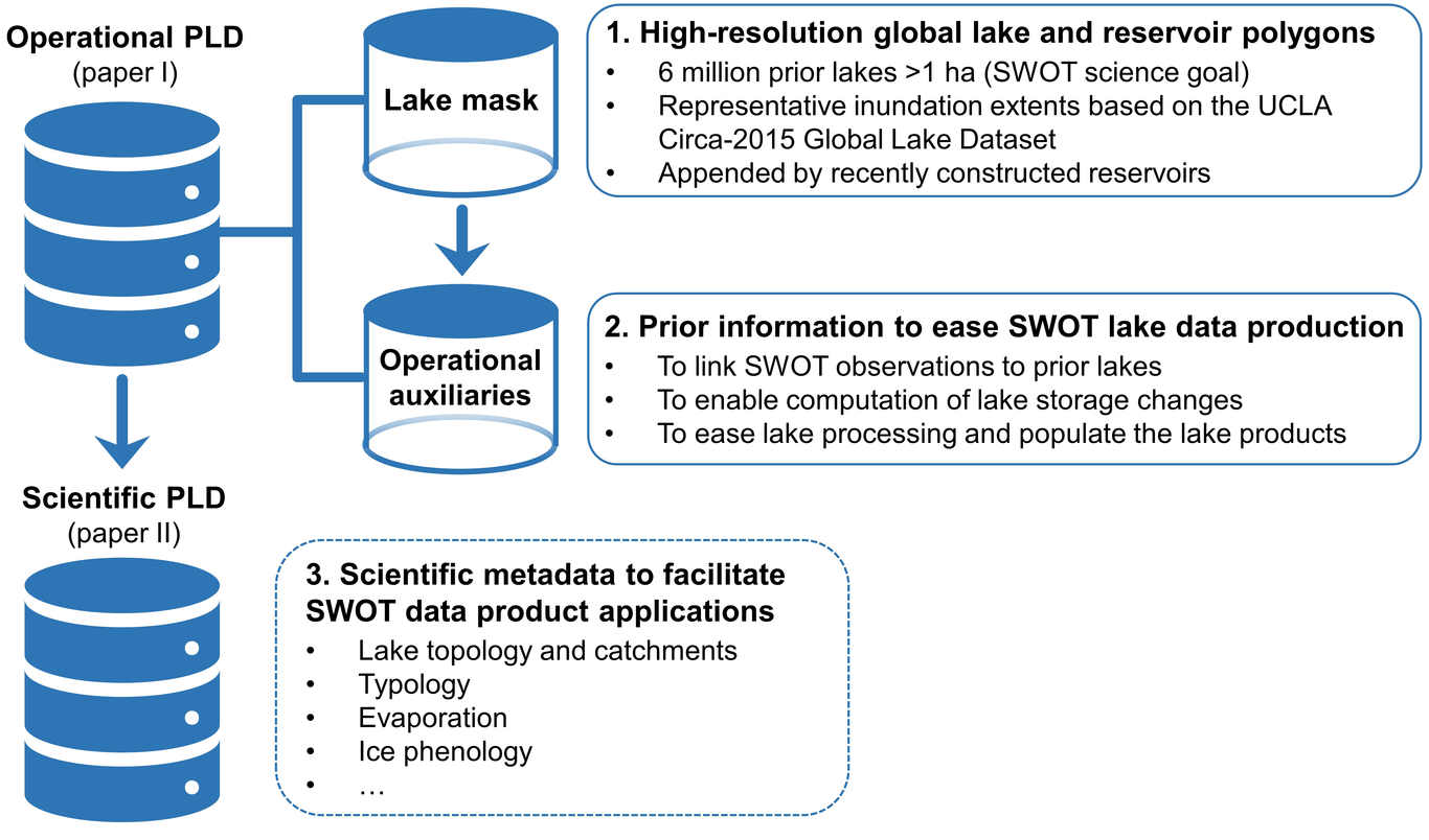
To help store water, facilitate navigation, generate energy, mitigate floods, and support industrial and agricultural production, people have built and continue to build obstructions to natural flow in rivers. However, due to the long and complex history of constructing and removing such obstructions, we lack a globally consistent record of their locations and types. Here, we used a consistent method to visually locate and classify obstructions on 2.1 million km of large rivers (width ≥ 30m) globally. We based our mapping on Google Earth Engine’s high resolution images from 2018–2020, which for many places have meter-scale resolution. The resulting dataset, the Global River Obstruction Database (GROD), consists of 29,877 unique obstructions, covering six different obstruction types: dam, lock, low head dam, channel dam, and two types of partial dams. By classifying a subset of the obstructions multiple times, we are able to show high classification consistency (87% mean balanced accuracy) for the three types of obstructions that fully intersect rivers: dams, low head dams, and locks. The classification of the three types of partial obstructions are somewhat less consistent (61% mean balanced accuracy). Overall, by comparing GROD to similar datasets, we estimate GROD likely captured 90% of the obstructions on large rivers. We anticipate that GROD will be of wide interest to the hydrological modeling, aquatic ecology, geomorphology, and water resource management communities.

Wayana Dolan

and 2 more

Within Arctic deltas, surficial hydrologic connectivity of lakes to nearby river channels influences physical processes like sediment transport and ice phenology as well as biogeochemical processes such as photochemistry. As the Arctic hydrologic cycle is impacted by climate change, it is important to quantify temporal variability in connectivity. However, current connectivity detection methods are either spatially limited due to data availability constraints or have been applied at only a single time step. Additionally, the relationship between connectivity and lake ice is still poorly quantified. In this study, we present a multitemporal classification and validation of lake connectivity in the Colville River Delta, AK. We introduce a connectivity detection algorithm based on remote sensing of water color that is expandable to other high-sediment Arctic deltas. Comparison to validation datasets suggests that detection of high vs. low connectivity lakes is accurate in 69.5–85.5% of cases. Connectivity temporally varies in about 20% of studied lakes and correlates strongly with discharge and lake elevation, supporting the idea that future changes in discharge will be drivers of future changes in connectivity. Lakes that are always highly connected start and end ice break up an average of 26 and 16 days earlier, respectively, compared to lakes that are never connected. Because spring and summer ice conditions drive Arctic lake photochemistry processes, our research suggests that surface connectivity is an important parameter to consider when studying biogeochemistry of Arctic delta lakes.