Yuning Shi

and 2 more

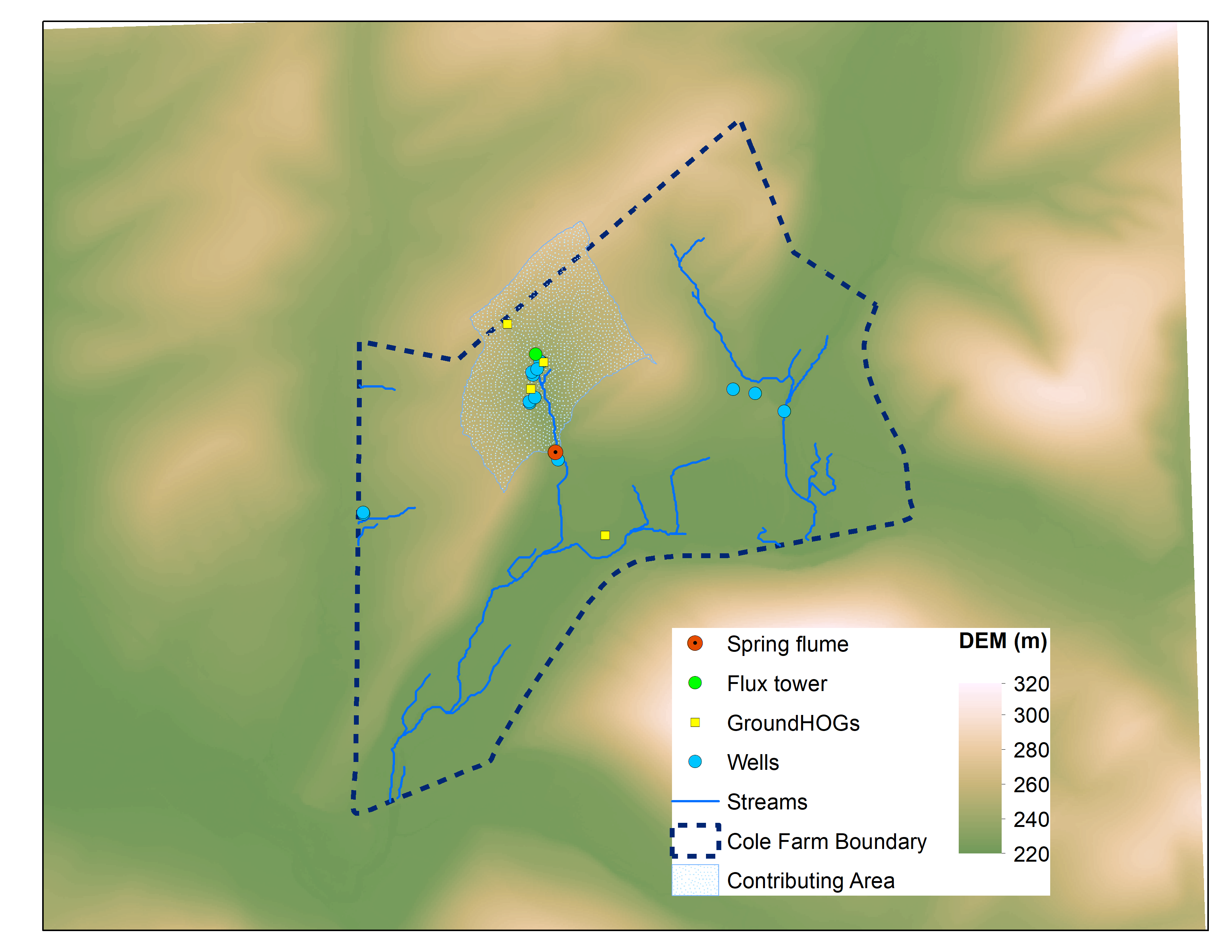
Managing landscapes to increase agricultural productivity and environmental stewardship requires spatially distributed models that can integrate data and operate at spatial and temporal scales that are intervention-relevant. This paper presents Cycles-L, a landscape-scale, coupled agroecosystem hydrologic modeling system. Cycles-L couples a 3-D land surface hydrologic model, Flux-PIHM, with a 1-D agroecosystem model, Cycles. Cycles-L takes the landscape and hydrology structure from Flux-PIHM and most agroecosystem processes from Cycles. Consequently, Cycles-L can simulate landscape level processes affected by topography, soil heterogeneity, and management practices, owing to its physically-based hydrologic component and ability to simulate horizontal and vertical transport of mineral nitrogen (N) with water. The model was tested at a 730-ha agricultural experimental watershed within the Mahantango Creek watershed in Pennsylvania. Cycles-L simulated well stream water discharge and N exports (Nash-Sutcliffe coefficient 0.55 and 0.58, respectively), and grain crop yield (root mean square error 1.01 Mg ha−1), despite some uncertainty in the accuracy of survey-based input data. Cycles-L outputs are as good if not better than those obtained with the uncoupled Flux-PIHM (water discharge) and Cycles (crop yield) models. Model predicted spatial patterns of N fluxes clearly show the combined control of crop management and topography. Cycles-L spatial and temporal resolution fills a gap in the availability of analytical models at an operational scale relevant to evaluate costly strategic and tactical interventions in silico, and can become a core component of tools for applications in precision agriculture, precision conservation, and artificial intelligence-based decision support systems.

Yuting Smeglin

and 8 more

An agricultural watershed, Cole Farm, was established as the newest of the three subcatchments in the Susquehanna Shale Hills Critical Zone Observatory (SSHCZO) in 2017. The catchment contains mostly pasture and crops, with a small portion of deciduous forest. The observations in Cole Farm afford an opportunity to test the spatially distributed land surface hydrologic model, Flux-PIHM, in farmland for the first time. In this study, we calibrated the model to only discharge and groundwater level observations at Cole Farm, but it’s able to capture the variations and magnitudes of soil moisture, latent heat (LE) and sensible heat (H) fluxes. Modeled soil moisture on the ridge top matched the observations well, but modeled soil moisture in the mid-slope differed from observations likely due to the existence of fragipan in the soil column. Flux-PIHM reproduced the seasonality and diurnal variations of watershed-average evapotranspiration (ET), sensible heat flux (H), though modeled ET in summer is about 25% greater than tower ET. To study the impact of land cover on hydrology, we imposed two different LAI forcings to the model: spatially distributed versus uniform LAI. Spatially distributed LAI produced higher ET and lower soil moisture in the forested part of the watershed due to higher LAI of deciduous forest in comparison to crops and pasture. But the impact of different LAI forcings on discharge was small. We further compared the water budget simulated by Flux-PIHM in the agricultural watershed (Cole Farm) to a forested watershed (Shale Hills). Flux-PIHM simulated less discharge and higher transpiration and bare soil evaporation in the Cole Farm watershed relative to Shale Hills watershed. Our work shows that with a few key observations, Flux-PIHM can be calibrated to simulate agricultural watershed hydrology, but spatially distributed LAI and soils data are needed to capture the spatial variations in soil moisture and ET.