Based on wintertime observations during the MOSAiC expedition in 2019-2020, it was found that Arctic cloud properties show significant differences when clouds are coupled to the fluxes of water vapor transport coming from upwind regions of sea ice leads.  Among these differences are that cloud liquid water path is considerably increased as  a function of lead fraction for observations of lead fraction above 0.02, whereas ice water path only shows some moderate level of dependency on lead fraction when deep precipitating clouds are considered. Cloud macro-physical properties like cloud base height and cloud thickness were found to be lower and thicker, respectively, for clouds coupled to the water vapor transport.To substantiate the findings from the MOSAiC data set, long-term measurements (2012-2022) at the U.S. Department of Energy (DOE) Atmospheric Radiation Measurement (ARM) at the North Slope Alaska (NSA) site in Utqiagvik, Alaska  are being used to study the climatology of clouds and their properties coupled to the sea ice concentration in the Western Arctic. The same methodology used for the MOSAiC study is feasible to be applied to the NSA ARM site thanks to the standard instrumentation dataset provided by the ARM program. The study focuses on the atmospheric boundary layer  topped  water vapor transport as mechanism to link  the influence of sea ice  leads or polynyas, to the clouds. Statistical results will be presented and set into context to the results found for the MOSAiC expedition.BERLING 2023 IUGG 28th GENERAL ASSEMBLY,  SESSION: M22d Cloud and Precipitation Studies, Convener: Greg McFarquhar (USA)
This study presents the micro- and macrophysical cloud properties as a function of their surface coupling state with the sea ice during the wintertime of the MOSAiC field experiment. Cloud properties such as cloud base height, liquid- and ice water content have been previously found to have statistically distinguished features under the presence of sea ice leads (characterized by sea ice concentration, SIC) along downwind direction from the central observatory RV  Polarstern. Those findings are mainly in an increase of liquid water content, and favored occurrence of low level clouds as contrasted to situations when the clouds are thermodynamically decoupled.The present contribution is an update considering two recent developments in the liquid detection in clouds and in the detection of sea ice leads. First, radar and lidar-based cloud droplet detection approaches like Cloudnet (Illingworth et al. 2007, Tukiainen et al. 2020) using Arctic wintertime observations and applied to measurements by the Atmospheric Radiation Measurement mobile facility (ARM) instrumental suite on-board the RV Polarstern during  MOSAiC.Secondly, we explore a new sea ice lead fraction product based on sea ice divergence. Sea ice divergence is estimated from sequential images of space-borne synthetic aperture radar with a spatial resolution of 700 m. The lead divergence product, being independent of cloud coverage, offers the unique advantage to detect opening leads at high spatial resolution.Statistics for the wintertime cloud properties based on the coupling state with the sea ice concentration and sea ice lead fraction will be presented as an approach to study Arctic clouds and their interaction with sea ice.
During the wintertime 2019-2020 of the Multidisciplinary drifting Observatory for the Study of Arctic Climate (MOSAiC) expedition, state-of-the-art remote sensing techniques have been used to study the observed dependency of the micro- and macro-physical cloud properties of low level clouds on the presence of sea ice leads in the vicinity of the RV Polarstern. It has been suggested that the water vapor transport (WVT) can be used as a mechanism to relate the cloud properties to the influence of sea ice leads quantified by the magnitude of sea ice lead fraction (LF). Among the findings are that clouds influenced by sea ice leads show a significant increase of liquid water path, cloud thickness and decrease in liquid phase cloud base height, as well as a slight dependency of total ice water content. Moreover, it has been found that the fraction of ice water content within the lowest cloud layer has a substantial difference when depicted as a function of cloud top temperature and segregated by the coupling status to the sea ice leads via the water vapor transport \cite{saavedra_garfias_asymmetries_2023}. This finding, however, considers the ice water fraction including the precipitating part of the cloud down to the surface. Therefore, the present contribution aims to study whether or not the snowfall shows a similar sea ice lead presence dependency when separated by the coupling status of the cloud-WVT-LF system. The extensive and meticulous study on the differences of snowfall estimated during the MOSAiC expedition performed by \citet{matrosov_high_2022a} , is exploited to easily add the different snowfall estimate dataset to the MOSAiC wintertime cloud properties dataset by \citet{garfias2023_datamosaic}.Presented at: 4th International Summer Snowfall Workshop, 11-13 September 2023, Leipzig, Germany.
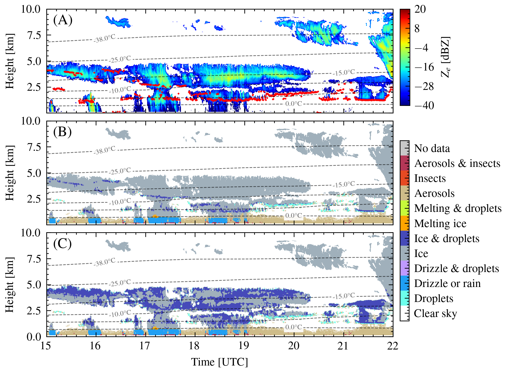
The current contribution presents wintertime climatology from 2012 to 2020 of mixed-phase clouds and their radiative effects when coupled to the sea ice states. Measurements from the U.S. Department of Energy (DOE) Atmospheric Radiation Measurement (ARM) at the North Slope Alaska (NSA) site in Utqiagvik, Alaska are being analyzed.Classification of cloud hydrometeors in the liquid, ice or mixed-phase states was primary determined by the Cloudnet algorithm, developed by the Finish Meteorological Institute, and applied to a set of ground-based remote sensing instruments from NSA . To evaluate the influence by sea ice, which plays an important role on the Arctic surface-atmosphere interaction, the statistics are separated into cases when clouds are coupled or decoupled to specific sea ice conditions, like presence of leads or polynyas in the vicinity of NSA .We found that clouds coupled to sea ice with presence of leads have shown distinguished features like the increase of total liquid content, lower cloud base heights and less ice content when compared to decoupled cases. Nevertheless, these results rely on Cloudnet accurately detecting cloud droplets within mixed-phase clouds. Arctic cloud radiative effects (CRE) have already been studied from short expeditions like the SHEBA campaign (Shupe et al., 2004) and middle-term ground observations in Barrow (Shupe et al., 2015) and Ny-Ålesund, Svalbard (Ebell et al., 2020). We extend similar CRE studies for 8 years during wintertime, where longwave up- and down-welling flux measurements from NSA are used to estimate surface net fuxes and other cloud radiative features for cases when clouds are coupled or decoupled to sea ice conditions and their sensitivity to different gradients of air-surface temperature when leads or polynyas are present. 
Long-term measurements at the U.S. Department of Energy (DOE) Atmospheric Radiation Measurement (ARM) at the North Slope Alaska (NSA) site in Utqiagvik, Alaska and from the Multidisciplinary drifting Observatory for the study of the Arctic Climate (MOSAiC) expedition are being used to study the climatology of clouds containing supercooled liquid (SCL) in the Western and Central Arctic. Classification of cloud hydrometeors in the liquid, ice or mixed phase of the cloud is determined by using the Cloudnet algorithm developed by the Finish Meteorological Institute. We apply the Cloudnet processing chain to a set of ground-based remote sensing measurements from the NSA site and the ARM mobile facility and the TROPOS shipborne atmosphere observation suite (OCEANET) on board of the RV Polarstern research vessel during MOSAiC. In order to accurately detect cloud droplets and SCL layers within mixed-phase clouds, Cloudnet relies on lidar observations. Lidars however suffer from total signal attenuation at a penetration optical depth of about three. Conversely cloud radars with their capability to penetrate multiple liquid layers can be used to expand the identification of cloud phase to the entire vertical column beyond the lidar signal attenuation height by using information of the cloud radar Doppler spectrum. The Leipzig Institute for Meteorology (LIM) recently developed a deep learning approach for reVealing supercOOled liquiD beyOnd lidar attenuatiOn (VOODOO) which benefits from the morphological features in cloud radar Doppler spectra to extract further information related to the existence of SCL using Cloudnet’s target classification as supervisor. The current contribution presents a SCL climatology obtained using Cloudnet for the NSA site along with case-studies for MOSAiC where VOODOO results are contrasted with the standard Cloudnet outputs. Advantages and limitations of both methods will be presented to the scientific community.
As part of the (AC)3 Arctic Amplification project, we are studying the influence of specific sea ice conditions like the presence of leads or polynyas on micro- and macrophysical cloud properties such as cloud fraction, altitude, thickness, thermodynamic phase, and their coupling state with respect to the underlying surface during the MOSAiC expedition’s legs 1 to 3. Micro- and macrophysical properties of surface-coupled clouds are analyzed as a function of sea ice concentration (SIC) in the vicinity of the ground-based atmospheric remote-sensing observations onboard the RV Polarstern. Only situations are analyzed where wind favored the transportation of air from location where open sea ice is detected. Cloud microphysical properties are obtained from the CloudNet cloud target classification algorithm which uses the atmospheric remote-sensing instrumentation suite on board of RV Polarstern provided by the US Atmospheric Radiation Measurement (ARM) mobile facility, the TROPOS ship-borne Atmosphere observation suite (OCEANET) and liquid water path retrievals by the University of Cologne. Primarily, the classical Matlab-based CloudNet classifications retrieved by TROPOS are used. Furthermore, the recently released ARM “evaluation” Active Remote Sensing Clouds (ARSCL) data product for the KA-band cloud radar is also evaluated by the new Python CloudNet version developed at the Finish Meteorological Institute. Discrepancies between those two CloudNet versions will be evaluated and reported as feedback for the ARM evaluation data set. High resolution (1-km) merged AMSR2-MODIS satellite retrievals of Sea Ice Concentration by the University of Bremen are used as information for sea ice monitoring. The present contribution only exploits SIC data, however future studies will focus on MOSAiC specific products for the classification of leads. Statistics for the cloud properties as a function of SIC will be presented as first approach to investigate the influence of sea ice conditions to central Arctic clouds.