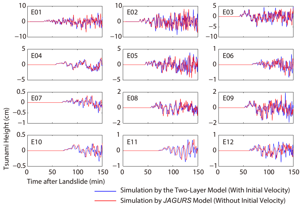
Osamu Sandanbata

and 5 more

Moderate earthquakes (Mw > 5) with moment tensors (MTs) dominated by a vertical compensated-linear-vector-dipole (vertical-CLVD) component are often generated by dip slip along a curved ring-fault system at active volcanoes. However, relating their MTs to ring-fault parameters has been proved difficult. The objective of this study is to find a robust way of estimating some ring-fault parameters based on their MT solutions obtained from long-period seismic records. We first model the MTs of idealized ring-faulting and show that MT components representing the vertical-CLVD and vertical strike-slip mechanisms are resolvable by the deviatoric MT inversion using long-period seismic waves, whereas a component representing the vertical dip-slip mechanism is indeterminate owing to a shallow source depth. We then propose a new method for estimating the arc angle and orientation of ring-faulting using the two resolvable MT components. For validation, we study a vertical-CLVD earthquake that occurred during the 2005 volcanic activity at the Sierra Negra caldera, Galápagos Islands. The resolvable MT components are stably determined with long-period seismic waves, and our estimation of the ring-fault parameters is consistent with the ring-fault geometry identified by previous geodetic studies and field surveys. We also estimate ring-fault parameters of two earthquakes that took place during the 2018 activity at the caldera, revealing significant differences between the two earthquakes in terms of slip direction and location. These results show the usefulness of our method for estimating ring-fault parameters, enabling us to examine the kinematics and structures below active volcanoes with ring faults that are distributed globally.

Yuchen Wang

and 4 more

The Eastern Mediterranean Basin (EMB) is under the threat of tsunami events triggered by various causes including earthquakes and landslides. We propose a deployment of Offshore Bottom Pressure Gauges (OBPGs) around Crete Island, which would enable tsunami early warning by data assimilation for disaster mitigation. Our OBPG network consists of 12 gauges distributed around Crete Island. The locations of OBPGs are confirmed by Empirical Orthogonal Function (EOF) analysis of the pre-calculated tsunami scenarios, and most of them are placed at the locations where the most energetic wave dynamics occur. We demonstrate three test cases comprising a hypothetical seismogenic tsunami in east Sicily, a hypothetical landslide tsunami in the Aegean Sea, and the real tsunami event of the May 2020 off the Crete earthquake. Our designed OBPG network achieves a forecasting accuracy of 88.5 % for the hypothetical seismogenic tsunami and 85.3% for the hypothetical landslide tsunami with warning lead times of 10-20 min for both cases. For the real event of May 2020, it predicts the tsunami arrival at tide gauge NOA-04 accurately; the observed and forecasted amplitudes of the first wave are 5.0 cm and 4.5 cm, respectively. The warning lead time for the May 2020 event was ~10 min. Therefore, our results reveal that the assimilation of OBPG data can satisfactorily forecast the amplitudes and arrival times for tsunamis in the EMB. We note that further studies are necessary to examine the relation between the performance of the system and the number of OBPGs or the tsunami characteristics.

Tung-Cheng Ho

and 8 more

An unusual devastating tsunami occurred on 28 September 2018 after a strike-slip faulting earthquake in Sulawesi, Indonesia. The induced tsunami struck Palu city with 4-m wave height and flow depth. We performed a two-step analysis to investigate the source of the tsunami. We first conducted the teleseismic source inversion and obtained the slip distribution of the strike-slip fault. Our tsunami simulation from the coseismic deformation of the seismically-estimated strike-slip faulting produced a tsunami comparable to the leading part of the observation at Pantoloan. We then jointly utilized the tsunami waveform and Synthetic Aperture Radar (SAR) data to reconstruct the detailed slip distribution on the fault plane. Because of the lack of SAR data in the bay, the tsunami data is necessary to constrain the offshore slip distribution, which directly induces the tsunami. The inverted source model shows a strike-slip fault which consists of three segments extending from the epicenter to the south of 1.4°S with two bends and two asperities around Palu city. The joint inversion model accurately reconstructs the observed surface displacements and the leading part of the tsunami waveform. Our result exhibits the significant contribution of the strike-slip faulting to the tsunami, but it also suggests additional tsunami sources, such as landslides, for the high inundations near Palu bay. The result also indicates that regional devastating tsunamis can result from an onshore strike-slip fault with localized large dip slip.