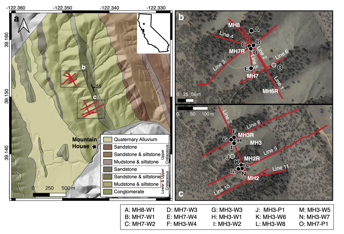
The structure of the critical zone is a product of feedbacks between hydrologic, climatic, biotic, and chemical processes. Ample research within snow-dominated systems has shown that aspect-dependent solar radiation inputs can produce striking differences in vegetation composition, topography, and soil depth between opposing hillslopes. However, more research is needed to understand the role of microclimates on critical zone development within rain-dominated systems, especially below the soil and into weathered bedrock. To address this need, we characterized the critical zone of a north-facing and south-facing slope within a first-order headwater catchment located in central coastal California. We combined terrain analysis of vegetation distribution and topography with field-based soil pit characterization, geophysical surveys and hydrologic measurements between slope-aspects. We observed thicker soil profiles, higher shallow soil moisture, and denser vegetation on north facing slopes, which matched previously documented observations in snow-dominated sites. However, average topographic gradient and saprolite thickness were uniform across our study hillslopes, which did not match common observations from the literature. These results suggest dominant processes for critical zone evolution are not necessarily transferable across regions. Thus, there is a continued need to expand critical zone research, especially in rain-dominated systems. Here, we present four non-exclusive, testable hypotheses of mechanisms that may explain these unexpected similarities in slope and saprolite thickness between hillslopes with opposing aspects. Specifically, we propose both past and present ecohydrologic processes must be taken into account to understand what shaped the present day critical zone.
Understanding how soil thickness and bedrock weathering vary across ridge and valley topography is needed to constrain the flowpaths of water and sediment production within a landscape. Here, we investigate saprolite and weathered bedrock properties across a ridge-valley system in the Northern California Coast Ranges, USA, where topography varies with slope aspect such that north facing slopes have thicker soils and are more densely vegetated than south facing slopes. We use active source seismic refraction surveys to extend observations made in boreholes to the hillslope scale. Seismic velocity models across several ridges capture a high velocity gradient zone (from 1000 to 2500 m/s) located ~4-13 m below ridgetops, that coincides with transitions in material strength and chemical depletion observed in boreholes. Comparing this transition depth across multiple north and south-facing slopes, we find that the thickness of saprolite does not vary with slope aspects. Additionally, seismic survey lines perpendicular and parallel to bedding planes reveal weathering profiles that thicken upslope and taper downslope to channels. Using a rock physics model incorporating seismic velocity, we estimate the total porosity of the saprolite and find that inherited fractures contribute a substantial amount of pore space in the upper 6 m, and the lateral porosity structure varies strongly with hillslope position. The aspect-independent weathering structure suggests the contemporary critical zone structure at Rancho Venada is a legacy of past climate and vegetation conditions.
The hazardous impact and erosive potential of slow-moving landslides depends on landslide properties including velocity, size, and frequency of occurrence. However, constraints on size, in particular, subsurface geometry, are lacking because these types of landslides rarely fully evacuate material to create measurable hillslope scars. Here we use pixel offset tracking with data from the NASA/JPL Uninhabited Aerial Vehicle Synthetic Aperture Radar (UAVSAR) to measure the three-dimensional surface deformation of 134 slow-moving landslides in the northern California Coast Ranges. We apply volume conservation to infer the actively deforming thickness, volume, geometric scaling, and frictional strength of each landslide. These landslides move at average rates between ~0.1–3 m/yr and have areas of ~6.1 x 10^3–2.35 x 10^6 m^2, inferred mean thicknesses of ~1.1–25 m, and volumes of ~7.01 x 10³–9.75 x 10^6 m^3. The best-fit volume-area geometric scaling exponent is γ ~ 1.2–1.5, indicating that these landslides fall between typical soil and bedrock landslide scaling. A rollover in the scaling relationship suggests that the largest landslide complexes in our dataset become large primarily by increasing in area rather than thickness. In addition, the slow-moving landslides display scale-dependent frictional strength, such that large landslide tend to be weaker than small landslides. This decrease in frictional strength with landslide size is likely because larger landslides are composed of higher proportions of weak material. Our work shows how state-of-the-art remote sensing techniques can be used to better understand landslide processes and quantify their contribution to landscape evolution and hazards to human safety.

W. Jesse Hahm

and 13 more

Bedrock weathering and soil production set the rate that hillslope colluvium is produced, while material properties determine whether sediment can fail under a given set of conditions. Together these factors generally control both the frequency and magnitude of landslides. In 2017, Puerto Rico (USA) experienced widespread landsliding across a range of lithologies due to Hurricane Maria, making it an ideal setting to explore the role of sediment generation in landslide response to storms. Based on an inventory of >70,000 landslides island-wide and detailed field mapping from a subset of source areas, we estimate that 0.01-0.1 km3 of material was evacuated from the hillslopes (approximately 1-10 mm of lowering). Focusing on the high-density landslide area of Utuado, we estimate an average lowering of 5-50 mm. From past inventories and records of storm events, a watershed is impacted by a hurricane every ~25 years with enough rain for widespread landslides every ~5 years. Assuming a similar density, the landslide contribution to hillslope lowering could be on the order of 1-10 mm/yr. In a humid-tropical environment, where weathering rates are likely high, can hillslopes continue to produce material at this pace? Elsewhere on the island, soil production rates are on the order of 0.1 mm/yr leading to soil residence times of approximately 10 ky. However, to keep pace with landslide events like Hurricane Maria, soil production likely needs to be at least an order of magnitude faster to maintain soil-mantled hillslopes in this study area. For our study area, we ask: has the large-magnitude rainfall from Hurricane Maria caused an abnormally high density of landsliding, resetting the clock on the material availability for areas like Utuado? Here we relate measures of material properties, bedrock weathering intensity, denudation, and land-use history to begin answering this question.
Understanding how soil thickness and bedrock weathering vary across ridge and valley topography is needed to constrain the flowpaths of water and sediment within a landscape. Here, we investigate how soil and weathered bedrock properties vary across a ridge-valley system in the Northern California Coast Ranges where topography varies with slope aspect such that north facing slopes, which are more densely vegetated, are steeper. In this study, we use seismic refraction surveys to extend observations made in boreholes and soil pits to the hillslope scale and identify that while soils are thicker on north facing slopes, the thickness of weathered bedrock does not vary with slope aspect. We estimate the porosity of the weathered bedrock and find that it is several times the annual rainfall, indicating that water storage is not limited by the available pore space, but rather the amount of precipitation delivered. Bedding-parallel and bedding-perpendicular seismic refraction surveys reveal weathering profiles that are thickest upslope and taper downslope to channels. We do not find a clear linear scaling relationship between depth to bedrock and hillslope length, which may be due to local variation in incision rate or bedrock hydraulic conductivity. Together, these findings, which suggest that the aspect-independent weathering profile structure is a legacy of past climate and vegetation conditions and that weathering varies strongly with hillslope position, have implications for hydrologic processes across this landscape.

Eric Fielding

and 9 more

The 4 July 2019 Mw 6.4 Earthquake and 5 July Mw 7.1 Earthquake struck near Ridgecrest, California. Caltech-Jet Propulsion Laboratory Advanced Rapid Imaging and Analysis (ARIA) project automatically processed synthetic aperture radar (SAR) images from Copernicus Sentinel-1A and -1B satellites operated by the European Space Agency, and products were delivered to the US and California Geological Surveys to aid field response. We integrate geodetic measurements for the three-dimensional vector field of coseismic surface deformation for thee two events and measure the early postseismic deformation, using SAR data from Sentinel-1 satellites and the Advanced Land Observation Satellite-2 (ALOS-2) satellite operated by Japanese Aerospace Exploration Agency. We combine less precise large-scale displacements from SAR images by pixel offset tracking or matching, including the along-track component, with the more precise SAR interferometry (InSAR) measurements in the radar line-of-sight direction and intermediate-precision along-track InSAR to estimate all three components of the surface displacement for the two events together. InSAR coherence and coherence change maps the surface disruptions due to fault ruptures reaching the surface. Large slip in the Mw 6.4 earthquake was on a NE-striking fault that intersects with the NW-striking fault that was the main rupture in the Mw 7.1 earthquake. The main fault bifurcates towards the southeast ending 3 km from the Garlock Fault. The Garlock fault had triggered slip of about 15 mm along a short section directly south of the main rupture. About 3 km NW of the Mw 7.1 epicenter, the surface fault separates into two strands that form a pull-apart with about 1 meter of down-drop. Further NW is a wide zone of complex deformation. We image postseismic deformation with InSAR data and point measurements from new GPS stations installed by the USGS. Initial analysis of the first InSAR measurements indicates the pull-apart started rebounding in the first weeks and the main fault had substantial afterslip close to the epicenter where the largest coseismic slip occurred. Slip on a NE-striking fault near the northern end of the main rupture in the first weeks, in the same zone as large and numerous aftershocks along NE-striking and NW-striking trends shows complex deformation.