Eva De Andrés

and 6 more

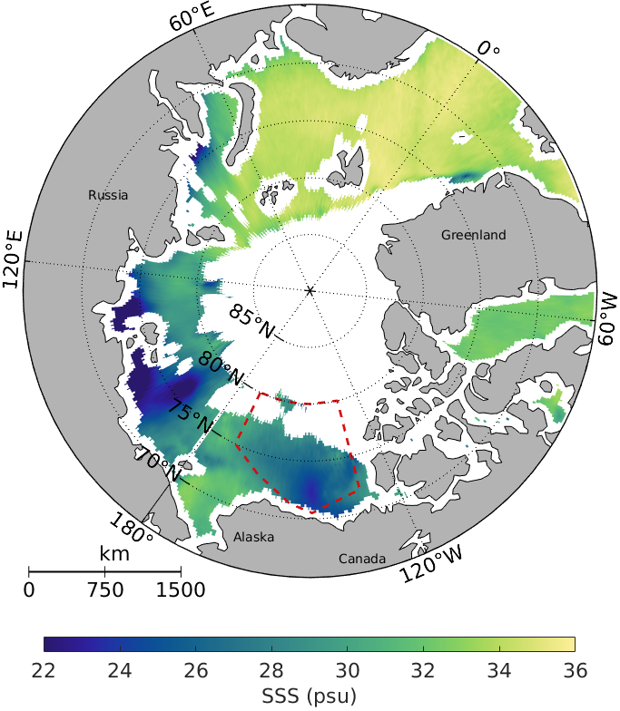
Arctic sea ice is retreating, thinning, and exhibiting increased mobility. In the Beaufort Gyre (BG), liquid freshwater content (FWC) has increased by 40\% in the last two decades, with sea ice melting being a primary contributor. This study utilizes satellite observations of sea surface salinity (SSS) and sea ice concentration, along with model-based sea ice thickness from 2011 to 2019. The aim is to investigate the sea ice-SSS relationship at different scales in the Arctic and understand the sea-ice meltwater dynamics in the BG. Our findings reveal a strong synchrony and positive correlation between sea ice area and SSS in the Arctic Ocean. In September, when the BG exhibits the largest ice-free ocean surface, a noticeable release of freshwater from sea ice melting occurs, a phenomenon not accurately reproduced by the models. The SMOS (Soil Moisture and Ocean Salinity) mission proves valuable in detecting meltwater lenses (MWL) originating from sea ice melting. These MWLs exhibit mean SSS ranging from 19 psu at the begining of sea ice retreat to 25 psu before sea ice formation. Wind-driven anticyclonic eddies can trap MWLs, preserving the freshest SSS imprints on the sea surface for up to 10 days. Furthermore, events of sea surface salinification following sea ice formation suggest that SMOS SSS might be capturing information on brine rejection. The daily evolution of sea ice-SSS within the MWLs demonstrates a tight correlation between both variables after sea ice melting and just before sea ice formation, indicating a transient period in between.

Justino Martínez

and 15 more

The Arctic Ocean contains only a 1% of the world’s ocean water, but the rivers that flow out into it account for the 10% of the volume world’s rivers freshwater. The upper layer of fresher water facilitates the creation of sea ice and plays an important role in the position of the jet stream and storms over the northern hemisphere [ISBN, 978-82-7971-097-4]. Remote sensing measurements are of special importance in the Arctic since in situ data is very scarce there. SMOS and SMAP are currently providing sea surface salinity (SSS) measures, but only the product provided by Barcelona Expert Center (BEC) is a dedicated product for the Arctic region. The product that we present in this work is an improvement of the BEC Arctic v2.0. The new version 3.0 has as the primary objective the describing better the river discharges. The spatial grid used is WGS84/NSIDC EASE-Grid 2.0 North for the all stages of the processing chain. This procedure avoids spatial interpolation, favoring the definition of river mouths. The salinity retrieval is based on the Debiased non-bayesian method [doi:10.1016/j.rse.2017.02.023] and similarly to what is done in the processing of altimetric data, SMOS salinity is corrected using a reference calculated from the own SMOS data for each latitude, longitude, pass orientation and antenna measuring position. Arctic v3.0 differs from current method [doi:10.3390/rs10111772] in two important points: the reference is computed for brightness temperature instead of SSS and the antenna has been divided in a more homogeneous grid. Other improvements concern to data filtering and propagation of the radiometric errors to SSS. All these improvements provide level 3 maps less noisy, increasing the effective resolution of salinity gradients. Freshwater gradients are much better resolved than in previous version (Fig. 1). Comparison with JPL SMAP product is also planned as a first step to generate a combined product. This work is funded by ESA Arctic + project and also includes the assimilation of the resulting SSS product in the ocean-sea ice data assimilation system TOPAZ as the next version TOPAZ5. A preliminary study [doi:10.5194/os-2018-163] has been performed concluding that BEC product could be a good candidate to be assimilated by TOPAZ. Moreover, some preliminary tests with a pre-release v3.0 version will start shortly.