Colin Byrne

and 4 more

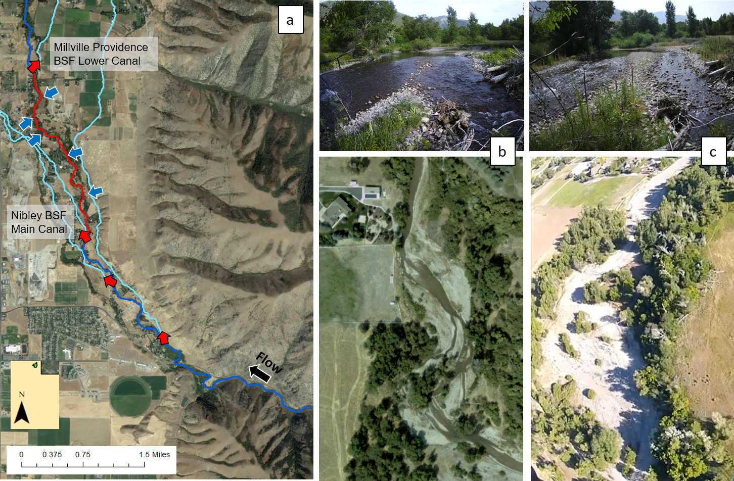
Reach-scale morphological channel classifications are underpinned by the theory that each channel type is related to an assemblage of reach- and catchment-scale hydrologic, topographic, and sediment supply drivers. However, the relative importance of each driver on reach morphology is unclear, as is the possibility that different driver assemblages yield the same reach morphology. Reach-scale classifications have never needed to be predicated on hydrology, yet hydrology controls discharge and thus sediment transport capacity. The scientific question is: do two or more regions with quantifiable differences in hydrologic setting end up with different reach-scale channel types, or do channel types transcend hydrologic setting because hydrologic setting is not a dominant control at the reach scale? This study answered this question by isolating hydrologic metrics as potential dominant controls of channel type. Three steps were applied in a large test basin with diverse hydrologic settings (Sacramento River, California) to: (1) create a reach-scale channel classification based on local site surveys, (2) categorize sites by flood magnitude, dimensionless flood magnitude, and annual hydrologic regime type, and (3) statistically analyze two hydrogeomorphic linkages. Statistical tests assessed the spatial distribution of channel types and the dependence of channel type morphological attributes by hydrologic setting. Results yielded ten channel types. Nearly all types existed across all hydrologic settings, which is perhaps a surprising development for hydrogeomorphology. Downstream hydraulic geometry relationships were statistically significant. In addition, cobble-dominated uniform streams showed a consistent inverse relationship between slope and dimensionless flood magnitude, an indication of dynamic equilibrium between transport capacity and sediment supply. However, most morphological attributes showed no sorting by hydrologic setting. This study suggests that median hydraulic geometry relations persist across basins and within channel types, but hydrologic influence on geomorphic variability is likely due to local influences rather than catchment-scale drivers.

Hervé Guillon

and 4 more

Statistical classifications and machine-learning-based predictive models are increasingly used for environmental data analysis and management. There now exist numerous classifications on the same topic but applied to different regions or spatial scales, such as geomorphic classifications. However, no quantitative meta-analysis framework exists to compare and reconcile across multiple classifications. To fill this gap, we jointly characterize statistical classifications and predictions by combining information theory and machine learning in three novel ways by: (i) measuring the degree of discriminatory information underlying a statistical classification; (ii) estimating the stability of the learning process with tuning entropy; and (iii) leveraging the sequential coarse-graining of information inherent to deep neural networks but absent from traditional machine learning models. This framework is applied through a benchmark of 59 millions models on a unique example of a single statistical classification methodology applied to nine different regions of California, USA. Regional results show that random forest consistently outperforms deep neural networks. In addition, a correlation analysis between regional characteristics, the level of discriminatory information of each classification, and the performance in statistical learning explains variations in performance and reveals the decisive role of the spatial scale of classification outputs. Because such a spatial scale is itself linked to the common situation of limited field sampling, directly comparing findings from statistical classifications and associated predictions appears seldom justified. A more desirable avenue to compare findings lies in combining data underlying statistical approaches in an interpretable and justifiable environmental data science.

Sara Alger

and 2 more

Irrigation activities are a major control on water movement and storage in irrigated river valleys in the Intermountain West, USA. Particularly in dry years, surface water diversions can deplete streams over the summer irrigation season, leading to more variable stream temperatures and increased risk for resident aquatic species. Cooler lateral inflows derived from irrigation activities can mitigate the impacts of depletion by buffering main channel stream temperatures. Given the increasing susceptibility of depleted streams to climate and land use changes, understanding stream temperature patterns and controls in these systems is critical. We used intensive field monitoring over three summers and thermal aerial imagery to characterize stream temperature patterns and irrigation influences in a 2.5 km reach of a small agricultural stream in northern Utah. Considering variable hydrology, weather, channel morphology, diversions, and lateral inflows we found stream temperatures to be relatively insensitive to flow depletion or lateral inflows in a wet year but very sensitive in drier years. Irrigation-related lateral inflows reduced longitudinal warming and diel variability during drier years and at times prevented temperatures from reaching stressful or lethal limits. Reaches with substantial lateral inflow contributions also had a greater areal proportion of low temperatures and spatial temperature diversity. These trends were enhanced by differences in channel morphology, with greater spatial and temporal variability in multi-thread than single-thread reaches. Study results highlight critical flow and weather conditions driving increased temperature variability that will likely become more extreme with additional climate change related reductions in baseflow. Regardless of the cause, this study highlights that decreased instream flows increase the importance of identifying, quantifying, and maintaining lateral inflows to maintain instream temperatures and preservation of these inflows should be considered in future water management decisions.

Belize Lane

and 4 more

The era of "big data'' promises to provide new hydrologic insights, and open web-based platforms are being developed and adopted by the hydrologic science community to harness these datasets and data services. This shift accompanies advances in hydrology education and the growth of web-based hydrology learning modules, but their capacity to utilize emerging open platforms and data services to enhance student learning through data-driven activities remains largely untapped. Given that generic equations may not easily translate into local or regional solutions, teaching students to explore how well models or equations work in particular settings or to answer specific problems using real data is essential. This paper introduces an open web-based learning module developed to advance data-driven hydrologic process learning, targeting upper level undergraduate and early graduate students in hydrology and engineering. The module was developed and deployed on the HydroLearn open educational platform, which provides a formal pedagogical structure for developing effective problem-based learning activities. We found that data-driven learning activities utilizing collaborative open web platforms like HydroShare and CUAHSI JupyterHub computational notebooks allowed students to access and work with datasets for systems of personal interest and promoted critical evaluation of results and assumptions. Initial student feedback was generally positive, but also highlights challenges including trouble-shooting and future-proofing difficulties and some resistance to open-source software and programming. Opportunities to further enhance hydrology learning include better articulating the myriad benefits of open web platforms upfront, incorporating additional user-support tools, and focusing methods and questions on implementing and adapting notebooks to explore fundamental processes rather than tools and syntax. The profound shift in the field of hydrology toward big data, open data services and reproducible research practices requires hydrology instructors to rethink traditional content delivery and focus instruction on harnessing these datasets and practices in the preparation of future hydrologists and engineers.