Jida Wang

and 17 more

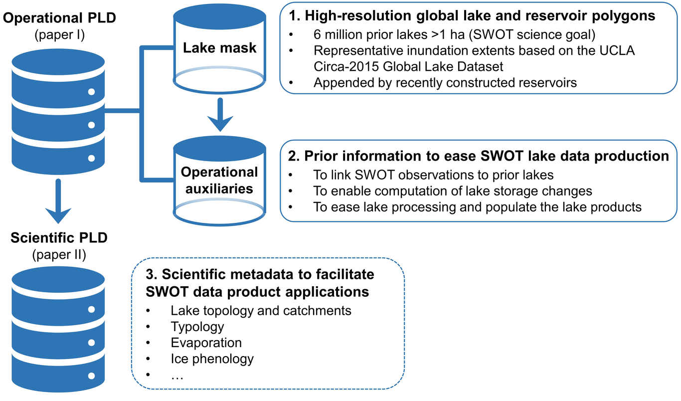
Lakes are the most prevalent and predominant water repositories on land surface. A primary objective of the Surface Water and Ocean Topography (SWOT) satellite mission is to monitor the surface water elevation, area, and storage change in Earth’s lakes. To meet this objective, prior information of global lakes, such as locations and benchmark extents, is required to organize SWOT’s KaRIn observations over time for computing lake storage variation. Here, we present the SWOT mission Prior Lake Database (PLD) to fulfill this requirement. This paper emphasizes the development of the “operational PLD”, which consists of (1) a high-resolution mask of ~6 million lakes and reservoirs with a minimum area of 1 ha, and (2) multiple operational auxiliaries to assist the lake mask in generating SWOT’s standard vector lake products. We built the prior lake mask by harmonizing the UCLA Circa-2015 Global Lake Dataset and several state-of-the-art reservoir databases. Operational auxiliaries were produced from multi-theme geospatial data to provide information necessary to embody the PLD function, including lake catchments and influence areas, ice phenology, relationship with SWOT-visible rivers, and spatiotemporal coverage by SWOT overpasses. Globally, over three quarters of the prior lakes are smaller than 10 ha. Nearly 96% of the lakes, constituting over half of the global lake area, are fully observed at least once per orbit cycle. The PLD will be recursively improved during the mission period and serves as a critical framework for organizing, processing, and interpreting SWOT observations over lacustrine environments with fundamental significance to lake system science.

Fangfang Yao

and 3 more

Improved monitoring of inundation area variations in lakes and reservoirs is crucial for assessing surface water resources in a growing population and a changing climate. Although long-record optical satellites, such as Landsat missions, provide sub-monthly observations at fairly fine spatial resolution, cloud contamination often poses a major challenge for producing temporally continuous time series. We here proposed a novel method to improve the temporal frequency of usable Landsat observations for mapping lakes and reservoirs, by effectively recovering inundation areas from contaminated images. This method automated three primary steps on the cloud-based platform Google Earth Engine. It first leveraged multiple spectral indices to optimize water mapping from archival Landsat images acquired since 1992. Errors induced by minor contaminations were next corrected by the topology of isobaths extracted from nearly cloud-free images. The isobaths were then used to recover water areas under major contaminations through an efficient vector-based interpolation. We validated this method on 428 lakes/reservoirs worldwide that range from ~2 km2 to ~82,000 km2 with time-variable levels measured by satellite altimeters. The recovered water areas show a relative root-mean-squared error of 2.2%, and the errors for over 95% of the lakes/reservoirs below 6.0%. The produced area time series, combining those from cloud-free images and recovered from contaminated images, exhibit strong correlations with altimetry levels (Spearman’s rho mostly ~0.8 or larger) and extended the hypsometric (area-level) ranges revealed by cloud-free images alone. The combined time series also improved the monthly coverage by an average of 43%, resulting in a bi-monthly water area record during the satellite altimetry era thus far (1992–2018). Given such performance and a generic nature of this method, we foresee its potential applications to assisting water area recovery for other optical and SAR sensors (e.g., Sentinel-2 and SWOT), and to estimating lake/reservoir storage variations in conjunction with altimetry sensors.

Pengfei Zhan

and 6 more

The inland lakes in the Tibetan Plateau (TP), with closed catchments and minimal human disturbance, are important indicators to climate change. However, examination of the spatiotemporal patterns of the Tibetan lake changes, especially for water level variation, was usually limited by inadequate measurement accessibility. This obstacle has been remedied by the developing satellite altimetry observations. The more recent studies revealed the growth tendency of lakes in the central TP had been decelerated or reversed during the period 2010-2016. It has not been systematically investigated whether the deceleration or hiatus would last in the following years thus far. This study aims to combine the traditional and recently-advanced altimetry observations to update our understanding of Tibetan lake changes in recent years. The results reveal that water level changes of the 22 examined lakes showed abrupt rises during the period 2016-2018, but the onsets and magnitudes of the rises varied among the lakes. During the study period, the water level of the nine lakes in the northern TP displayed a drastic rising trend with an average rate of 0.82 m/a. In the central TP, the lake level changes were generally divided into two categories. The water levels for the lakes in the western CTP rose rapidly, while in the eastern CTP, the lake water levels rose slowly with an average rising rate less than 0.40 m/a. The water levels for lakes in the northeastern TP and northwestern TP kept a stably rising tendency. According to the results of climate analysis, the spatial differences of the lake level rise rates were primarily caused by the spatial and temporal changes of precipitation over the TP, which may be related to the large-scale atmospheric circulation affected by the El Niño and La Niña events.