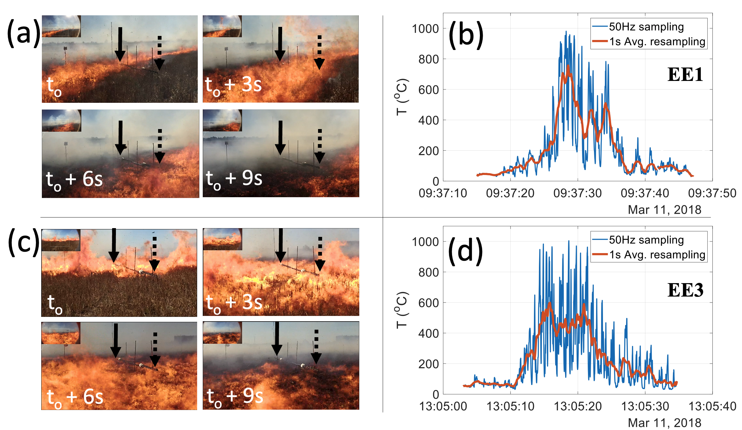
Eva Bendix Nielsen

and 3 more

 We have characterized the magnitude and spatial extent of observed regional and inter-regional air temperature trends and warming extremes across Antarctica. Prior studies have used localized observational records to analyze air temperature trends across distinct geographical regions, leaving local and inter-regional variations to be undetected. Using the high-resolution temperature product AntAir ICE, air temperature trends and extreme warming events during austral summers were identified across Antarctica for the period 2003-2021. Unsupervised clustering was applied to austral summer and annual mean air temperature trends to divide Antarctica into 12 regions exhibiting similarity in temperature trends. Our results show a significant annual mean cooling trend of - 0.12 °C/Yr for the terrestrial Antarctic Peninsula, and an austral summer (annual) warming trend of + 0.08°C/Yr (+0.07 °C/Yr) in the Ross Sea region’s Victoria Land and Transantarctic Mountains. The spatial extent of each of the 12 clusters’ extreme air temperature events was mapped revealing that West Antarctica has spatially confined events, while East Antarctica events are widespread. ERA5 data indicates that West Antarctica's extreme air temperature events are associated with consistent meridional atmospheric flows. Local to regional extreme warming events in East Antarctica are associated with inland high-pressure systems, which enhance katabatic winds. Localized warming events around complex coastal geographies were detected and appear to be related to mesoscale wind systems such as foehn but require further investigation using mesoscale numerical weather models. This work highlights the necessity for ongoing and new monitoring in regions where critical ecological and physical thresholds are being surpassed.

Marwan Katurji

and 18 more

We present novel in-field vegetation fire observations, and the analyses used to process the data, using brightness temperatures recorded by longwave infrared camera and thermal image velocimetry. The brightness temperatures from a wind-driven stubble wheat fire were obtained in video format with a 60 frames per second (fps) acquisition rate. Multi-level sonic anemometers mounted on a 10m in-fire tower were used for in-situ measurements of turbulent velocity and air temperatures, while fuel level air and flame temperatures were collected by an array of thermocouples. The camera’s image pixel resolution was adequate to resolve dynamics and in accordance with the in-fire thermocouple spacing distances. The in-situ and remotely measured flaming zone dynamics were derived using two different methodologies, Thermal Image Velocimetry (TIV) and Image Segmentation (IS). The results highlight spatial and spectral information of coherent turbulent and mean velocity structures. The power spectra decomposition of the thermal image velocimetry showed similar spectral characteristics to the sonic velocity measurements during the fire passage under the tower with a similar inertial subrange slope. This result reveals plausible evidence of interaction between the flaming zone and wind turbulence for a prescribed rapidly moving stubble wheat fire. This research presents a new field measurement methodology for understanding fire-atmospheric interactions between the flaming zone and the immediate overlying atmospheric turbulent boundary layer.